
0. General information
The Physics of The Biblical Flood
by Roi Lotan Glazer
Copyright Ⓒ December 9, 2012 By Roi Lotan Glazer
My written permission is required for any commercial use of the material, which is displayed in this book (please use the email q.spacer@gmail.com to contact me). Do not print this book without written permission. Nevertheless, permission is granted to quote segments and even whole chapters from this book and the illustrations in the book may be used freely for any non-commercial use. The permission includes press and web sites from any type. Any text, picture or illustration must be attributed to its original creator (in correlation with the data that is attached to the picture or illustration). Any illustration in this book, that is not attributed to an external source, is the product of my own work. Feel free to contact me by email with any question.
Language Editor: Tamar Ben Yosef
Rabbinical examination: Rabbi Yosef Aharoni
Contact information: website: www.q-spaceTheory.org, email: q.spacer@gmail.com, phone: (972)54-5369363, Israel.
On the cover: Light and Shadow in the Carina Nebula (cosmic cloud). Image Credit: NASA, the Hubble Heritage Team and Nolan R. Walborn (STScI), Rodolfo H. Barba' (La Plata Observatory, Argentina), and Adeline Caulet (France).
0.2 Acknowledgments
Acknowledgments
I would like to give thanks to my family, for their faith and support, to Rabbi Yosef Aharoni for his professional and spiritual assistance, to David Teich and Uriel Farjon for their constant help and advice, to Arnon Segal and Yosef Ruso for their major help in the exposure of my theories in Israel, to Rabbi Yonadav Zar, Shulamith Velikovsky Kogan and Dr. Hadassah Melamed for their referrals, information, advice and ongoing cooperation and to all the scientists who previewed this theory throughout its development, but asked to remain anonymous. In addition I also thank the staff of Mari B gas platform for enabling me to practice endless hours of explanations on them and to the readers of the Israeli magazine “Olam Katan” (עולם קטן) for participating in the previewing and improvement of this theory. In addition I would also like to thank Yoav Miller for his voluntary professional assistance with the construction of the web site.
1. Preview
Background and method:
I define myself as an independent scientist, who is researching a variety of subjects in the domains where science and spirituality are connected. During the years 2001-2005 I studied electrical engineering and physics at the Tel-Aviv university. In the summer of 2005, while I searched for a way to intuitively understand relativity, I found a geometric breakthrough, which will enable us to understand the source of space-time and unite relativity with quantum mechanics. From the first moment that the initial idea of this theory occurred to me, all that I wished for was to research it thoroughly. Because of time and money constraints, it was clear to me that I could not devote enough time to my research, if I continued with my studies. Therefore, I immediately stopped my studies and focused on the issue, which I saw as paramount. A senior professor of physics, who read part of the material, encouraged me to continue with my research and I hope to present its conclusions soon. More material regarding my personal background and method of research is available on my web site (as for now- only in Hebrew):
:החזון, המטרה והשיטה של מדעםרוח" בדף "מדעםרוח" באתר"
I was an atheist until 2005. Due to the spiritual insights, which emerged from my research, I became a believer. Gradually, I became more and more interested in my original religion- Judaism. The most holy books in the Hebrew Bible are the five books of the Torah (Genesis, Exodus, Leviticus, Numbers, Deuteronomy). It is in the Jewish tradition to devote a period of time in every week in order to study a weekly Torah portion. In total, traditional Jews read the Torah over and over again in year-long cycles. While studying the weekly portions, it became clear to me, that I could settle some of the greatest "contradiction" between science and Torah. The research given here is a product of this process. This research, like others which I am conducting, is not of the type that can be published through normal academic channels. One of the professors of physics, who read a draft of this research, phrased it in the following manner: The theory is possible. However, since I know the world of academia, I think they would not accept it. The appropriate forum to advance your theory would be in the annual Torah-Science conference.
I thank the mentioned professor for his genuine feedback, but his answer disturbed me. Certainly, those who already believe in the Torah would be glad to read about a theory, that would further strengthen their beliefs. But I do not wish to limit this knowledge to a specific community. Assuming that my theories are right (in part or in whole), we are speaking about knowledge, that can alter concepts of whole societies. Bringing together and combining science, the Torah and spirituality in general, will produce a message of morality and peace for all. It will aid in bringing together different people, societies, religions and nationalities. It will become easier and more natural to understand and respect each other, while preserving our own uniqueness. There will be no Utopia and it will not solve all the problems of humanity, but it will indeed improve the world. Therefore, I am ready to risk my reputation in order to bring this knowledge to the public worldwide. If my theories will be proven as wrong, the embarrassment will be mine alone. Humanity will not be harmed. On the other hand, if my theories will be proven right (even if only partially), then all of humanity will gain.
My intention is to produce a worldwide public discussion. My hope is that this discussion will also trigger the academic community to thoroughly examine my theories. The theories that I will present contain dozens of claims, which can be scientifically tested in experiments and verified with findings. The logic in every theory will be clear and everyone will be able to examine it and try to disprove it. Most of the claims can be addressed scientifically. I call the scientists in the relevant domains to try and disprove the theories. I will not ask anyone to blindly accept my claims. If errors are found, I will not hesitate to admit them, even if a whole theory will collapse by doing so.
If my theories are indeed based on a firm logical-scientific foundation, then they will be able to survive the initial academic response. In any case, I presume that there will be many critics. Scientific history shows, that nearly every scientific revolution had to deal first of all with a strong academic opposition. It is as if academic trends have inertia. They (nearly) always resist sharp reformation. I address both the public and the scientists and request:
Within this process, please pay attention and know how to separate genuine scientific criticism from other (inappropriate) types of criticism.
On the threshold of a revolution, those who mock tend to draw a lot of public attention in the short run, especially if they use high academic language and they have a respectable degree. However, the scientific history teaches us that the same mockers, who tend to draw the most attention in the short term, also have the greatest chance to be remembered in the long term in a negative context after the revolutionary concept becomes the convention. It is no secret that ego also plays a role in academic circles. Scientific theories should not rise or fall due to ego motivated battles. Who knows how many great and revolutionary ideas were never published merely because of fear from the expected reaction. That is an ego motivated reaction. What does the academic world really wish for? Do we not wish for an establishment, in which everyone has the right and freedom to express his ideas without fear? Do we not wish for an academy that will cultivate creativity? The scientific community, who wishes to represent progress, freedom of speech and creativity actually suffocates these same values many times with its own hands. I hope that this time, things will be conducted differently.
The only relevant criticism for scientific theories is a specific criticism, which refers to specific issues in the research. This type of criticism disproves different claims by presenting contradicting findings and/or by exposing logical errors (for example computation errors or unjustified conclusions). When publishing decent criticism, the other side must be notified and given the opportunity to appropriately respond. The scientific truth is not necessarily well-expressed under the spotlights and it doesn't pop out of one's sleeve. It is not determined by the ratings. It must be researched thoroughly. It demands time and it should eventually be published in writing.
I am starting the presentation of my theories from "The Physics of The Biblical Flood", because this is the first theory, that has matured enough to be presented to the public. The issue itself poses one of the greatest "obstacles of faith" in the Torah. So great, that even some of the religious scientists, with whom I corresponded, did not believe that it actually occurred. When dealing with the Biblical flood, we will have to deal with other essential issues in the book of Genesis. Therefore, the Biblical flood poses a junction, from which we can practically settle most of the "contradictions" between science and the book of Genesis. I hope, that I will have the means, to continue and present additional theories in the near future.
"And I, behold, I establish my covenant with you, and with your seed after you; And with every living creature that is with you, of the fowl, of the cattle, and of every beast of the earth with you; from all that go out of the ark, to every beast of the earth. And I will establish my covenant with you, neither shall all flesh be cut off any more by the waters of a flood; neither shall there anymore be a flood to destroy the earth."
(Genesis 9: 9-11, King James' translation)
As we begin to dive deeper and deeper into the scientific inquiry of the Biblical flood, we may get the feeling, that the flood was just an extreme natural phenomena, which could occur again in the future. Although it sometimes seems to the scientists as if everything is merely physics, chemistry and mathematics, I claim that there is a deeper spiritual truth. For God, the laws of physics and chemistry are work-tools. The powers of nature are a channel, through which his will can be expressed. These claims, as for now, are claims of faith rather than scientific claims. If we trust the Torah, we will have the faith, that humanity will never experience a catastrophe of that scale again. That faith will calm the believer's heart.
What the Torah teaches:
The verbal meaning of the word "Torah" in its original language (Hebrew) is: teaching and instructing. From its name we can infer its main purpose. The Torah's purpose is not just to supply us with technical and historical knowledge. It's purpose is to teach and instruct us. First of all, the Torah comes to teach and instruct us with moral and practical spiritual knowledge. If humanity as a whole had merely made the effort to obey the ten commandments, our situation would have been much better than it is today. It is not by chance that the expression "he has no God" is commonly used to describe someone, who performs evil acts without any conscience or fear.
Besides the spiritual and moral knowledge, the Torah also contains a lot of "technical" data and descriptions of physical events. Some seem to conform more or less with our recorded historical experience and seem reasonable (dryads and famine in the land of Canaan; descriptions of the ancient Egyptian kingdom; descriptions of the ancient economies; ancient nations and so on...). While some of the data seems to most people as stories of miracles or fairy-tales. For most of the secular sector and even for some in the religious sectors, the Biblical description of the flood is easily categorized as a "myth" or "legend". Allegedly, the Biblical flood is merely a vague memory of some ancient flooding event, but it surely isn't an accurate physical description.
Dealing with the scientific research of the Torah's integral "technical" knowledge does not detract from the power of its moral and spiritual purpose. On the contrary, in our generation more than ever, when so many people rely so much on scientific understanding and proof, by proving the Torah's "technical" knowledge its prestige will rise. The amplification of its moral and spiritual message will then naturally follow.
Can the Torah generally be regarded as a credible source?
In our day (2012), the most common answer in the halls of academia to the title's question is probably "NO". The secular public thirstily drinks the lectures, opinions and beliefs of those that represent academic authority. Therefore, the answer in the secular public will probably be identical. In general, the Torah is perceived by the secular public as a fairy-tale. Indeed, the academic authority does have strong claims that seem to undermine the credibility of the Torah. They base their claims on findings in many scientific domains.
Science by itself rightfully gained its prestige amongst the public due to its amazing and undoubted technological achievements. Every electric instrument, every engine, every plastic vessel (and the list can go on...) prove that the scientific method works. However, there is a great gap between the facts that can be proven to a high degree of certainty and the interpretations and beliefs of the scientists themselves. The general public (as well as part of the scientific community) is not aware enough of the existence of this gap. Throughout scientific history, there were many cases in which scientists fanatically preserved their academic beliefs and refused to accept new ideas, even when contradicting scientific evidence piled up against them. The fact that such a phenomena exists in academia is by itself proof that some scientists are motivated by their personal beliefs more than by pure science.
Science- Respect it and suspect it.
Respect its capabilities, but know its limits.
You can probably guess that I claim that the Torah is actually a reliable historical document (much more than what most of us currently imagine). In this research, we will see how the technical details in the description of the Biblical flood, which seem most bizarre, suddenly become obvious and scientifically make sense. The mystery surrounding one of the most peculiar portions of the Torah will soon fade away. The status of the Biblical flood as a myth will begin to crack.
2. Regional flood or global flood?
In the 1999 book "Noah's Flood: The New Scientific Discoveries About the Event That Changed History" (Simon & Schuster), the Columbia University geologists Drs. William B.F. Ryan and Walter C. Pitman theorized that the sealed Bosporus strait, which acted as a dam between the Mediterranean and Black seas, broke open because of climatic warming at the end of the last glacial period. This caused the icecaps to melt, raising the global sea level. With more than 200 times the force of Niagara Falls, the thundering water flooded the Black Sea, then no more than a large lake, raising its surface up to six inches per day and swallowing 60,000 square miles of land (155,400 square kilometers) in less than a year. As the Mediterranean salt water replaced fresh water, it caused a wave of human migration from what had been an oasis of fresh water within very arid lands.
They claimed that the exodus was traumatic enough to be recorded in human memory as the epic of Gilgamesh and the Biblical story of "Noah's Flood." Their theory was based on their discovery of a single, uniform layer of mud that strongly indicated a flood. Sediment core samples revealed sun bleached freshwater mollusks, fossilized plant roots and cracks in the buried mud indicating that it had once been a dried out and windswept land surface. 1
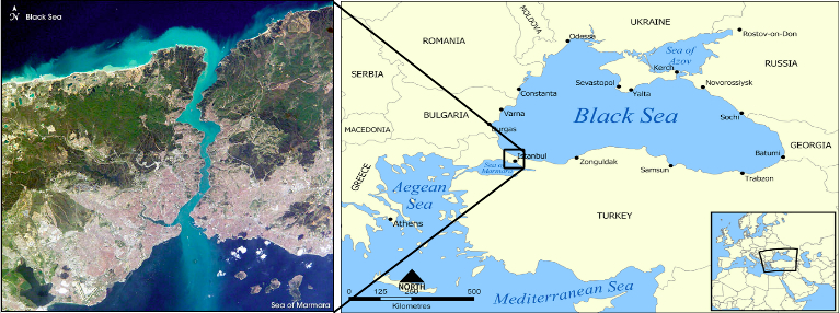
The Bosporus strait connects the Black Sea with the Mediterranean Sea. The width of the strait is less than 700 meters (0.42 miles) at its narrowest site and its depth ranges between 60-110 meters (196-360 feet) 2 . During the ice age, while the sea level wa s low, the strait was dry and the Black Sea was a disconnected sweet water lake. Ryan and Pitman claim that the breaking of the strait at the end of the ice age is the origin of the Biblical flood myth.
(Map creator: Norman Einstein 3 , Satellite image: NASA 4 )
During the years 1999-2000 a comprehensive geological and archeological research was conducted on Ryan and Pitman's theory. The research proved that the Black Sea was indeed a sweet lake until about 7,600 years ago. Then tens of thousands of square kilometers were rapidly flooded. The most amazing findings were the remains of neolithic settlements along the ancient coastline. The detailed information and the story of the expedition are available on National Geographic's web site (Ballard- The Black Sea, The Search for Noah's flood ) 5. Since the year 2000, Ryan and Pitman's theory has gained academic recognition as the ultimate explanation for the flood "myth". I also, as an avid science enthusiast and a former atheist, was fascinated by their theory.
For a long time scientists and other researchers have tried to connect the Biblical flood to a variety of regional floods from different historic and prehistoric eras. Some of them coincide (more or less) with the dating of the Biblical flood (during the 3rd millennia B.C.) while others relate to much older flooding events (as in the case of the Black Sea flooding). In the Israeli Bar Ilan University, the academic staff traditionally publishes a "weekly page" relating to the corresponding weekly Torah portion. On the weekly page corresponding to the Biblical flood (year 2001) 6, Professor Moshe Kaveh (the president of the university) briefly reviewed the flood related research that was conducted until then. Among other things, he also mentioned the new findings relating to the Black Sea flooding. The academy usually regards the Biblical flood7 as no more than a regional flood. The main reason for this conclusion is the lack of a reasonable scientific explanation for a global flood mechanism, which flooded the entire world all the way up to the summit of mount Ararat (the final resting place of the ark). Over and over again scientists claim that there simply isn't enough water in our world to enable such flooding. They also claim that there is no geological and archeological evidence to support such an event.
In addition to the regular academic claims, Moshe Kaveh referred to several sources in the rabbinical tradition, which might imply that the Biblical flood was indeed regional:
"Already in the writing of the old rabbinical sages there is a representation of the concept, that the scope of the Biblical flood was regional. According to Rabbi Johanan (tractate Zevachim 113, 72), in the land of Israel the rain of the flood did not come down. And in "Torah Temimah" it is written: "And what lasted in Babylon more than in the entire world that it was submerged in the flood. It should be said according to tractate Zevachim that therefore Babylon was named Shinar, because all the dead of the flood were shaken there" (in Hebrew the verb "ninar" means "to be shaken". So the word "Shinar" can be interpreted as "that which was shaken"). "And the commentary is that it (Babylon) is very deep, hence she was also called Depths." In the conception of the rabbinical sages, Babylon is the entire world, as may be inferred from Pirke De-Rabbi Eliezer (chapter 10): "And all the people sat in one place fearing the waters of the flood and Nimrod was their king, as said 'and his kingdom was Babylon'".
-
Professor Moshe Kaveh mentioned in this short segment several rabbinical sources that are well known to any traditional Jew. However, I imagine that most of the readers here have never heard of them prior to this book. "Tractate Zevachim" is a portion of the "Mishnah". The Mishnah, like the Hebrew Bible is a massive masterpiece. It contains the summary of rabbinical oral knowledge and discussions throughout a period of some 500 years (ending at 70 C.E.). "Torah Temimah" is a commentary on the Torah that was published by the Lithuanian Rabbi Baruch Epstein in the year 1902. Pirke De-Rabbi Eliezer is a book of additional tales and legends, which complete and retell the stories of the Torah. It is attributed to Rabbi Eliezer Ben Hyrcanus, who lived at the end of the first and beginning of the second centuries C.E. All the texts were originally written in Hebrew. I translated the text above to English.
Personally, I found it difficult to accept that any of the regional flood theories do indeed coincide with the accurate Biblical description of the flood. Especially with the following verse:
"And the waters prevailed exceedingly upon the earth; and all the high hills, that were under the whole heaven, were covered. Fifteen cubits upward did the waters prevail; and the mountains were covered."
(Genesis 7: 19-20, King James' Translation8)
And what about the above mentioned commentaries of the rabbinical sages? Actually, their commentaries are not as unequivocal as they were presented in the quoted weekly page. In fact, there was a long-lasting discussion regarding the questions: Was the land of Israel flooded? And if it was flooded to what extent was it flooded? Was there any rain in the land of Israel or was it only flooded by the water that flowed into it from the surrounding areas? Were the inhabitants of the land of Israel killed by the flood or by the extreme heat that is related (in the rabbinical commentaries) to the flood? and so on... In the rabbinical discussions it is accepted that no conclusive decisions should be made, unless it becomes a necessity due to immediate practical needs. Therefore, there is no actual rabbinical decision regarding the Biblical flood.
One of the most appreciated rabbinical commentaries are those of Ramban (Rabbi Moshe Ben Nahman Girondi), who lived in medieval Spain (1194-1270 C.E.). In his commentaries (for Genesis 8: 11) he quoted from Pirke De-Rabbi Eliezer (chapter 23) the following conclusion:
"The waters of the flood did not pour down on the land of Israel from the heavens, but rolled in to it from the surrounding lands".
Two additional most appreciated rabbinical commentaries are those of Rashi and Ibn Ezra. Rashi (Rabbi Shlomo Yitzhaki) lived in southern France and predated the Ramban by more than a century (1040-1105 C.E.). Ibn Ezra (Rabbi Abraham Ben Meir Ibn Ezra) lived in Spain shortly before the Ramban and slightly after Rashi (1089-1167 C.E.). The combined commentaries of Ramban, Ibn Ezra and Rashi are the most commonly used commentaries on the different publications of the Hebrew Bible. Furthermore, most publications of the Hebrew Bible do not display any other commentaries at all.
If we combine the commentaries of Rashi, Ibn Ezra and the Ramban (for Genesis 7: 19-20) then it becomes clear that these commentaries (which are regarded as the best of all commentaries) emphasized that the flood was global and not regional. So wrote Rashi:
"Fifteen cubits above: Above all the peaks of all the mountains, after the waters were equal to [at the same level as] the mountain peaks. [from Gen. Rabbah 32:11]"
And so wrote Ibn Ezra:
"' Exceedingly powerful.' That there is nothing more powerful than it (the flood). A nd also after he said that all the lofty mountains were covered up, why is it said (again) that the mountains were covered up? And this is the commentary: that every high mountain was covered up with water and that the mentioned mountains were covered up with 15 cubits of water."
I do not see how one can interpret from these commentaries that the flood was regional. Even the land of Israel was flooded (although the rain did not pour directly on it).
Actually, all the regional flooding theories, including the Black Sea flooding (which I personally accepted until the year 2010) presume that the Biblical description is exaggerated. Personally, I knew very well all along that the Black Sea flood theory cannot accurately satisfy the Biblical description. Nevertheless, I was willing to accept it since I also regarded the Biblical description as exaggerated. Such an approach is understandable. Based on the world (as we know it today) it seems difficult to imagine how the sea level rose so high, that all the highest mountains sank beneath the water. How did all the water disappear after the flood? Is there enough water in the world for such an event in the first place?
Anyone who studies the Biblical description of the flood finds very long and detailed descriptions, regarding the different stages of the flood, its sources, its duration, its level and so on. From my knowledge of the Torah, I know that there are usually very little physical descriptions. If the Torah makes an effort to give so many details about a specific physical event, it implies that it is intended to deliver an unequivocal message to the reader. The author of the Torah made a great effort to supply the reader with the most accurate information in order to emphasize that this event was real.
Now the question is: Is it possible to scientifically explain (with our present scientific knowledge) how and if such a flood could occur? If it is possible, what findings should we expect to find and how may we prove or disprove its existence?
1 Suzanne Trimel Columbia University, NYC. Discovery of Human Artifacts Below Surface of Black Sea Backs Theory by Columbia University Faculty of Ancient Flood . 09/13/00. http://www.earthinstitute.columbia.edu/news/story9_1.html
2 Leonid I Ivanov and Temel Oguz. Ecosystem modeling as a management tool for the black sea. Nato science series, 2. Environmental Security- Vol. 2, page 1 (1997). http://www.springer.com/earth+sciences+and +geography/oceanography/book/978-0-7923-5245-7
6 http://www.biu.ac.il/jh/parasha/noah/noah.shtml .פרופסור משה קווה, המבול והמדע, הדף השבועי לפרשת נח- שנת ה'תשס"ב
7 This is correct up to the year 2012 and includes research from previous decades.
8 All the quotations from the Bible in this book are taken from The holy Bible, King James version Electronic Text Center, University of Virginia Library. http://etext.virginia.edu/toc/modeng/public/KjvGene.html
3. The stages of the flood
Actually, the author of the Torah has made an effort to supply us (with great detail) all the information that is needed in order to understand the physical aspects of the flood. It is possible to retrieve a lot of information from the Torah and its commentaries. It seems that there is a consensus on certain issues in the different commentaries, while in other issues there are fundamental disputes. However, in order to solve the physical enigma of the flood, there is no need at this initial stage to discuss every verse (and specifically there is no need to study the disputes and try to decide between them). It will just suffice to emphasize the division of the Biblical scenario to 3 fundamental stages, which are sharply distinct from each other.
Stage 1: 40 days of continuous rain:
The Biblical flood began "...[on] the same day were all the fountains of the great deep broken up, and the windows of heaven were opened." (Genesis 7: 11, King James' translation). And then it rained continuously for 40 days: "And the rain was upon the earth for forty days and forty nights" (Genesis 7: 12, King James' translation).
Stage 2: 150 days in which the waters "prevailed" upon the earth:
" And the flood was forty days upon the earth; and the waters increased, and bare up the ark, and it was lift up above the earth. And the waters prevailed, and were increased greatly upon the earth; and the ark went upon the face of the waters. And the waters prevailed exceedingly upon the earth; and all the high hills, that were under the whole heaven, were covered. Fifteen cubits upward did the waters prevail; and the mountains were covered ... And the water prevailed upon the earth a hundred and fifty days."
(Genesis 7: 17-24, King James' translation)
It is a common mistake to think that the rain merely lasted 40 days. After the initial 40 days the rain may not have been continuous, but it did not necessarily stop. Actually, according to Rashi and Ibn Ezra the level of the waters just continued to rise. During the 150th day, the level of the waters also covered the highest mountain in the world 15 cubits above its summit! On the other hand, Ramban argued that most of the rise in the water's level took place during the first 40 days, however the level did not begin to decrease until the 150th day.
Do 150 days include the initial 40 days of rain from the first stage? There was a dispute in this issue between Rashi and Ramban. According to Rashi, 150 days are added to the initial 40 days of rain. According to Ramban, 150 days included the initial 40 days of rain. As for now, there is no need to further investigate the details of this dispute. The main point is to merely understand that the sea level rose, flooded the entire world and did not begin to decrease before the end of this stage. 150 days are approximately 5 months. Hence, the waters "prevailed" upon the earth 5-6 months!
Stage 3: The calm and prolonged decrease of the water's level (approximately 6 months):
This stage begins when a mysterious wind passes over the earth and the storm stops:
"And God remembered Noah, and every living thing, and all the cattle that was with him in the ark: and God made a wind to pass over the earth, and the water s assuaged; The fountains also of the deep and the windows of heaven were stopped, and the rain from heaven was restrained;"
(Genesis 8: 1-2, King James' translation)
Rashi comments: "'and God made a wind to pass': A spirit of consolation and calm passed before Him. [Targum Jonathan and Yerushalmi]. 'over the earth': Concerning [events on] the earth. 'and the waters assuaged': Heb. וַיָּשֹׁכּוּ, like (Esther 2:1): "when the king’s fury assuaged (כְּשֹׁךְ)," an expression of the calming of anger.[from Tan. Buber Noach 12]. 'the springs ' (instead of "fountains"- there is a translation error in King Jame's version of genesis) '…were closed': When they were opened, it was written (7: 11): "all the springs," but here,"all" is not written, because some of them remained [open], those that were necessary for the world, such as the hot springs of Tiberias and the like. [Gen. Rabbah 33:4]. ' was withheld ' (instead of "restrained" in King James' translation): Heb. וַיִכָּלֵא , and it was withheld, like (Ps. 40:12):"You will not withhold ( תִכְלָא ) Your mercies" ; (Gen. 23:6):"[None of us] will withhold ( יִכְלֶה ) from you."
Ibn Ezra comments: "'...and God made a wind to pass'. it passed continuously until the waters assuaged. '...and the waters assuaged' the waters rested and did not prevail like (Esther 2:1): "when the king’s fury assuaged". 'The fountains…were stopped' they were closed. '... the rain from heaven was restrained'. locked within the treasure." Ibn Ezra's "treasure" is not like a pirate's treasure. The atmosphere treasures a great quantity of water within it (as humidity). It releases some of its waters as rain and dew. The ancient sages understood well that even during a dryad the air "locks" waters within it, but does not "release" it. The following use of the word "treasure" strengthens this explanation:
"The LORD shall open unto thee his good treasure, the heaven to give the rain unto thy land in his season, and to bless all the work of thine hand..."
(Deuteronomy 28:12, King James' translation)
It is evident from this verse that the sky is routinely regarded as the treasure of the water. Therefore, Ibn Ezra's phrase "locked within the treasure" merely means that the sky did not release any more rain. I thank Matanya Ofan for assisting me with this issue.
It is probably not easy for most readers to understand the phrases of the commentaries. Even traditional Hebrew speaking Jews find themselves sometimes struggling with the texts. Translating these commentaries to English just complicates the matter since a lot of information may be lost along the way. Anyway, we can still reach important physical conclusions. It seems obvious that the waters were stormy until this stage. Then, when a wind passed over the earth, the waters calmed down. It is very important to notice that from this moment on, the rain stopped completely ("the rain from heaven was restrained") and the springs of the deep were also stopped ("The fountains also of the deep and the windows of heaven were stopped"). This event took place on the 150 th day and stands out in the Biblical flood as a sharp and clear boundary between the second and third stages.
From this day on the water level gradually decreased. Noah's ark rested upon Mount Ararat (Genesis 8: 4), 73 days later (according to the Ramban) the mountain tops were seen (Genesis 8: 5), after another 40 days Noah opened the ark's window and sent the raven (which didn't find a resting site for his feet!), one week later the dove was sent for the first time (she too found no resting site for her feet) and only after an additional week the dove found the famous olive leaf. In total, we can see that the water level did indeed decrease, but the process of revealing the land lasted at least 4-5 months. Only 10 and a half months (more or less) after the beginning of the flood, it is finally said that "the waters were dried up from off the earth" (Genesis 8: 13).
In summary , the 3 major stages of the Biblical flood are:
-
Stage 1 : 40 days of continuous rain.
-
Stage 2 : 150 days in which the water prevailed upon the earth. Stage 1 may be included within the beginning of this stage.
-
Stage 3 : The calm and prolonged decrease of the water's level (more or less 6 months).
Conclusion: Any physical theory, which presumes to accurately describe the Biblical flood, must first of all explain how a global flood occurred and then satisfy all of the given stages by their order and duration.
4. Can the flood be explained as a mega-tsunami?
From the Biblical description it is evident that the flood was a prolonged process. The flooding was gradual and so was the decrease in the water's level. I have read presumptions, which theorize that the Biblical flood was a tsunami. A "normal" tsunami is created by a strong earthquake and does not lift the sea level more than 30 meters. Furthermore, the temporary rise in sea level is merely local. Therefore, it cannot generate a global flood. On the other hand, an asteroid impact in one of the oceans could generate a "mega-tsunami", that may wash over extensive parts of our planet. Can the Biblical flood be explained as a mega-tsunami?
The geologists divide our planet into "spheres". This term originates from the Greek word "sphaira" which verbally meant "ball". However, today we use this term to describe a surface or the enveloping of a ball. The atmosphere (which we all know) is the gaseous sphere that envelopes the surface of the planet ("atmos" means "vapor" in Greek). Similarly, since most of our planet is covered by water, the hydrosphere ("hydro" = "water" in Greek) was defined as the (incomplete) sphere of the oceans, seas, lakes, rivers and groundwater (down to several kilometers or miles beneath the ground).
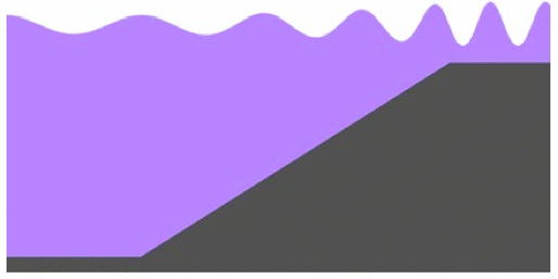
Today, around three quarters of the earth's surface is surrounded by water (oceans and seas). The hydrosphere is demonstrated (in an exaggerated and disproportional manner) in the following illustration by the blue stripe enveloping most of earth:
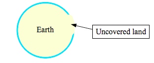
Earth and its hydrosphere in the "normal" state.
As I explained in the previous chapter, the water level decrease (during the 3rd stage of the flood) is described as gradual and prolonged. During the final months of the flood, the water was calm and silent rather than stormy. Hence I conclude that only a global flood, which is expressed by a massive (but temporary) addition of water to the hydrosphere, can accurately satisfy the Biblical description. The following illustration demonstrates (in an exaggerated and disproportional manner) the swelling of the hydrosphere (compare with the previous illustration):
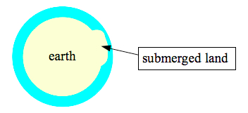
Earth and its swollen hydrosphere during the flood.
The impact of a great celestial body (like an asteroid) falling in one of the oceans could have caused mega-tsunamis (see the following illustration below). In other words giant waves spread out at high velocities and flooded vast areas of land. In addition, the impact might have generated strong earthquakes (from its shock wave). These quakes and their own aftershocks may have caused additional "regular" tsunamis. But (allegedly) the quantity of water in the hydrosphere shouldn't have changed in this scenario. Therefore the hydrosphere would not have swollen, but "only" experienced concussions that would have transported quantities of water from one area to another. In contrary to the Biblical description, the characteristics of the floods should have been violent and stormy all throughout the phenomena. The first waves should have been the highest. I cannot imagine how such an impact generated a flood as described in the calm, silent and prolonged characteristics of the third stage.
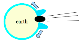
An asteroid impact could have created mega-tsunamis, but the hydrosphere would not have swollen. Hence, this scenario does not satisfy the third stage of the Biblical flood and cannot (alone) explain it.
Conclusion: The Biblical flood was not generated by an asteroid impact.
5. Can the flood be explained as an extreme tide?
Routinely, the gravity of the moon (and to a less extent: the sun) creates small tides in the seas and oceans. If some massive celestial body (like an asteroid, comet or another planet) passes close enough to earth (close like the moon or even less), it will also cause tides. The intensity of the tides will depend on the mass of the celestial body and on how close the encounter with the body will be. A closer encounter will cause stronger tides. A more massive body will also cause greater tides. Some researchers have theorized in the past that a close encounter of this type created tidal forces so strong that the waters of the oceans swept over the land and even covered the mountain tops.
In order to understand why this explanation is not satisfactory, we must add to our knowledge of the physics of tidal forces. Although the initial aim of this explanation is to negate the theories, which relate the Biblical flood to a close encounter with a celestial body, the following explanation is most important for this research and it will be worthwhile to understand it. The explanation is deliberately written in popular and figurative language.
The pulling force of the moon is a "gravitational force". Gravity is (as we well know) a pulling force that bodies (with mass) operate on each other. Due to gravity we are pulled towards the earth and we do not risk jumping straight into space every time that we skip for fun. The same force also has an important (but not exclusive) role in preserving the stable orbits of the planets around the sun and of the moon around earth. If we could have stopped the motion of the earth and moon and then left them alone, they would have been drawn to each other by their gravity and the moon would have quickly crashed upon earth. Luckily, the moon has an initial velocity in a perpendicular direction to earth. The mere existence of this velocity creates an opposing and balancing force named the "centrifugal force". The centrifugal force is the force that we feel when we drive in a sharp turn. It is the force that aims to throw the turning body away from its track. Due to this force we can ride upside-down in the roller coaster without falling.

The centrifugal force is the force that aims to throw us out of track while driving in a bend. Due to it we can ride up-side down in the roller coasters without falling.
(Source of picture: Boris23)1
In the next illustration I am trying to demonstrate how the Moon retains a stable orbit due to the balance between the forces acting upon it. The balance is achieved in an orbit where the intensity of the centrifugal force is equal to that of the gravitational force of earth (the intensities are actualized by the lengths of the arrows).
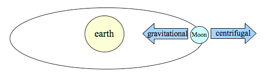
The Moon remains in a stable orbit around Earth due to the balance between the gravitational force (which Earth operates upon) to the centrifugal force that originates from its own motion (inertia).
The intensity of the gravitational force, that is that one body operates upon another body, depends on its mass and distance. And if we speak about the Moon, the intensity of the gravitational force that the Moon operates on bodies upon Earth depends on the Moon's mass (which is a constant datum) and on its distance from the body (which varies according to the body's location upon Earth). A person who is standing on Earth's Moon facing side (point A in the following illustration), is around 12,700 kilometers (7,891 miles) closer to the Moon than his friend, who is standing on the opposite side (point B in the following illustration). Therefore, the gravitational pull that the Moon operates upon a person standing on Earth's side facing the Moon, is greater than the gravitational pull that the Moon operates on a person standing on the opposite side of Earth. People standing on different locations on Earth (like points C and D in the illustration) are subjected to intermediate intensities of Moon related gravitational pull depending on their specific distances from the Moon.
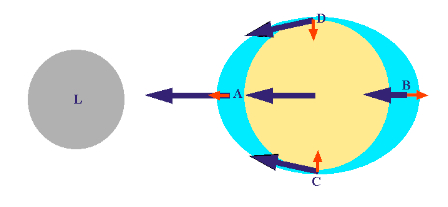
Moon's gravitational pull (blue arrows).
The blue arrows in the illustration above do indeed demonstrate the differences in the intensities of the Moon's gravitational pull on different locations on Earth, but they do not practically express the tidal forces. The tidal forces are expressed in the illustration by the red arrows. Why? In a figurative phrasing, it is because every body in Earth "has" to take in account, that it is still part of the whole Earth. Despite the limited freedom of maneuver of some of the bodies upon Earth, the whole planet still reacts as one unit to the Moon's pull.
For example, imagine that you are trying to pull your friend with a rubber band (one that doesn't easily tear apart. See in the next illustration). First you pull and stretch the rubber band, but your friend remains motionless. Only when you pull with greater force your friend begins to move with you. At this situation, when your friend is lagging behind you, the rubber band will remain stretched. And since the band is stretched the distance between the two of you is now greater than it was in the initial state. Your friend wishes to stay behind, but eventually he must move together with you since he is tied to you.
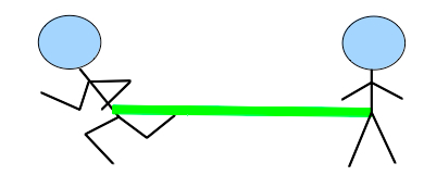
The left man begins to pull the right man with a rubber band...

Only after greater force is applied does the left man manage to move his friend. Now they both move together while the rubber band remains stretched...
The intensity of the average pull , that the Moon operates upon a body on Earth (or more precisely upon a mass unit), is demonstrated, in the previous illustration, by the blue unsigned arrow in Earth's center. This arrow represents the intensity of the Moon's gravitational pull, which every mass on earth would have "felt" had it been located in its center. The center of Earth is also the center of its gravity. This practically means that if we sum up the Moon's gravitational pull on the entire Earth and then divide it by Earth's mass, it will turn out that the force per unit as mass is identical to that which operates upon a unit in Earth's center. The tidal forces at any given point upon Earth actually express the difference between the Moon's gravitational pull at that specific point and the average Moon's gravitational pull (per unit mass) upon the entire Earth.
In the rubber band example it is clear that if the right man will move together with the left man at exactly the same speed and from the first moment, then there will be no need to stretch the band and the distance between them will remain unaltered. The difference in the initial speeds of the men is what forced the left man to stretch the rubber band. The band was stretched and the distance between them grew. Similarly (but not identically), the differences in the intensity of the Moon's pull (per unit mass) upon different locations on earth practically stretch the entire planet. The bodies at point A are pulled towards the Moon more than those in any other location, and therefore there is a high tide at point A. The bodies at point B are pulled towards the Moon less than those at any other location, and therefore a body at point B is equivalent to the right man that is dragged behind. This drag generates a high tide in point B too!
The dragging effect is not just a metaphor. Earth as a whole does not stay still in relation to the Moon. It actually "dances a tango" with it. The light and enthusiastic Moon likes to spin around Earth, while the Heavy and clumsy Earth just takes one step forward, each time in a different direction (in correlation with the Moon's changing position).
The low tides at points C and D originate from the fact that the Moon's pull is diagonal (in relation to the Moon-Earth axis) at these locations. The diagonals slightly bend towards the center of Earth. The difference between the Moon's average pull on earth (per unit mass) to the actual pull at these points counterbalances any horizontal effect. However, since the average pull is only horizontal, there is no factor to counterbalance the vertical effect of the original diagonal pull at these points. Therefore, the remaining force (after counterbalancing) pushes downward and creates low tides.
Earth's own rotation (which defines the duration of a "day") causes two high tides and two low tides per day at every specific location. For example point A will rotate together with Earth to replace point C after 6 hours, point B after 12 hours, point D after 18 hours and so on...
Now that we have understood (I hope) the foundations of the physics of tidal forces, let us return to our issue. Why do I claim that the Biblical flood could not have been caused merely by some close encounter with a massive celestial body?
-
Because a close encounter with a celestial body should be a short event (like the passing of a comet) and the Biblical flood on the other hand lasted nearly a year.
-
Because such high and low tides should have generated intensive currents and stormy waters all throughout the phenomena. This determination contradicts the characteristics of stage 3 (the calm and silent stage).
-
Because the tides were (allegedly) formed from the hydrosphere's existing reservoir. But this reservoir cannot supply the quantity of water that is needed for the globally calm and stable flood, which characterizes stage 3.
Conclusion: The Biblical flood was not caused merely by a close encounter with some massive celestial body.
So far, I have merely negated several popular flood theories. I have explained why the flood must have been global and not regional (negating all the regional theories). I have also explained why the Biblical description of the flood stands in contradiction to the asteroid impact or the extreme tide theories. Have we now reached a dead end? Let us return to the Torah itself...
6. Clues for the true nature of the flood?
It is written in the book of Genesis that the flood originated both from the opening of "the windows of heaven" and the breaking of " the fountains of the great deep" (Genesis 7:11, King James' translation). Whatever the "windows of heaven" and the "fountains of the great deep" are, it is clear that the flood was bidirectional: both from the heaven and from the great deep. This bidirectional flood did not stop at once, but gradually in a prolonged process. Furthermore, even after God stopped the fountains of the great deep and the windows of heaven (Genesis 8: 2), it took a very long time for the water to disappear from above the land (at least 4-5 months). The duration of the whole flood was an entire year. The first 5-6 months were stormy (stages 1 and 2) and the following 6-7 months were characterized as a catharsis, with no rain, wind or harsh waves (stage 3). Why was the flood prolonged and where did the water eventually go?
The crucial question for solving the physical enigma of the Biblical flood is this:
Do we understand what the "windows of heaven" and the "fountains of the great deep" really are?
Allegedly, it seems logical to presume that the fountains of the great deep relate to ground water. In the original Hebrew text it may even seem to make more sense, because the term that is used instead of "fountains of the great deep" can be verbally translated as "the ground waters of the great deep". Already in ancient times humans have seen how water flows out of the ground and they knew very well how to dig wells to reach the hidden groundwater reservoirs. We see how water is eventually reached nearly every time we drill into the earth. But the author of Genesis did not merely write "ground water". He added the Hebrew word "רבה" (pronounced as "ra-ba"). This word implies that the subject is not normal ground water, but some other type of water, which lies far beneath in the great deep. And this mysterious water was pumped all the way up in a most unusual phenomena only once in the history of mankind. It is most important to understand that the Bible does make a clear distinction between normal groundwater and the water of the great deep. Especially due to the fact that geological research teaches us that there simply isn't enough groundwater in the earth's crust to satisfy the Biblical flood.
At this point in my research I had to assume a "working assumption", which can be phrased as following:
Working assumption: Deep within Earth there are indeed great quantities of water, which can flood the entire face of the planet, exactly as the Bible describes.
-
I will present supporting evidence for this presumption in the following chapters.
Assuming that the necessary water does indeed lie somewhere in the great deep, what could have caused it to suddenly burst forth towards the surface of the Earth? In order to answer this question we must first understand the meaning of the phrase "the windows of heaven". It would be wise to reexamine the definition (by fact) of the concept "heaven" in the book of Genesis:
"And God said, Let there be a firmament in the midst of the waters, and let it divide the waters from the waters. And God made the firmament , and divided the waters which were under the firmament from the waters which were above the firmament : and it was so. And God called the firmament Heaven ..."
(Genesis 1: 6-8, King James' translation)
"And God said, Let there be lights in the firmament of the heaven to divide the day from the night..."
(Genesis 1: 14, King James' translation)
The "firmament" divides between the waters and God calls the firmament "heaven". But the "firmament of the heaven" also contains the celestial lights; i.e. the stars, the planets, the Sun and the Moon. The definition of "heaven" in Genesis does not merely refer to our atmosphere. It refers to the entire Space! The entire Space? Of course! What does Space actually "do" rather than form a separation between star and star, between the sun and sun, hydrogen and hydrogen, water and water? I know this may sound a bit vague. I will elaborate on this idea immediately.
Most of the stars that we see in the sky are in fact suns. In other words, they resemble our own sun in their fundamental characteristics and composition. However, they are very distant and therefore merely appear as tiny twinkling dots of light in our sky. The main component of suns (or stars) is the element Hydrogen. It is not an accident that the word "Hydro" originates from the ancient Greek term for water. A strong and evident connection between the words "Water" and "Hydrogen" also exists in Hebrew (Water: "ma-yim": מים, Hydrogen: "may- man": מימן). Water molecules are combined from two Hydrogen atoms and one Oxygen atom. It turns out that Space practically separates between Hydrogen concentrations (which are the stars).
Even if we merely examine the planets of our solar system, it will turn out that the most common constituent is Hydrogen. The reason for this result is derived from the fact that 92% of the planet's mass is concentrated in merely two giant planets: Jupiter and Saturn 1. Jupiter and Saturn are by themselves composed mostly of Hydrogen (around 80% in the atmosphere2 and around 50-67% in their inner parts 3).
Maybe the Biblical separation between the waters actually refers to the separation between Hydrogen concentrations, which in fact defines the formation of the stars and planets? Is the word "water" ("ma-yim") in Genesis (chapter 1) actually the Biblical way of describing the most abundant element in our universe: Hydrogen ("may-man"), an element which was probably unknown (as a separate material) for most people (if at all) until the modern era.
To open the windows of heaven would practically mean to blur the separation between the waters (or between materials in general) that Space itself defines.
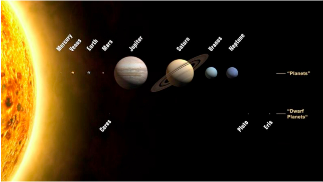
The Sun and the planets are presented in their real scale and order. Jupiter and Saturn alone contain 92% of the mass of the planets. These gas giants are mainly composed from Hydrogen, so Hydrogen is in fact the main constituent of the planets.
(Picture source: NASA 4 )
Can a massive meteoroid shower supply an explanation for the opening of "the windows of heaven"? Unlike an "asteroid", a "meteoroid" is a relatively small and harmful object. When a meteoroid falls into our atmosphere, it melts and decomposes (due to its friction with the air) and we view the spectacular phenomena which is popularly called a "shooting star". It is known that many of the meteoroids are in fact small ice blocks. Ice meteoroids, which penetrate the atmosphere completely melt and decompose on their way down and do not reach the ground. Their ice becomes water vapor and joins Earth's own atmospheric water. In a massive meteoroid shower the meteoroid related waters may condense and generate rain. One of the interesting points of this scenario is that Earth may be bombarded with tremendous quantities of meteoroids while keeping its surface intact. Therefore, craters are not expected to form. It is only expected to generate pouring rain. According to the Bible, 40 days and nights of continuous rain!
Another possibility is that Earth was swallowed up by a cosmic "dust" cloud (which is abundant in Space). If this cloud contained Hydrogen, then the penetration of its Hydrogen to Earth's Oxygen-rich atmosphere would have generated water by combustion. Any lightning could have ignited the combustion. The intense rain would have naturally followed.
The second scenario does not replace the first one. On the contrary, it is possible and reasonable that both scenarios coexisted. Cosmic clouds may in fact be composed of meteoroids. In other words, a cosmic cloud may actually be a cloud of meteoroids. It may also have a diverse composition and contain both icy meteoroids and molecular Hydrogen.
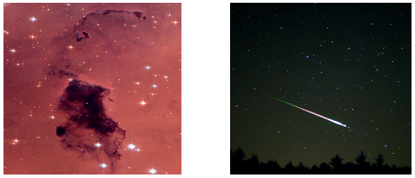
Pictures of a cosmic cloud (on the right) and a meteoroid penetrating the atmosphere (on the left).
(Picture's source: NASA)
Can we now finally solve the physical enigma of the Biblical flood? We may have gone several steps forward in the right direction, however, before we can declare that we have achieved some practical theory we must pay attention to the following point: it is unlikely, that the waters of the flood originated from Space. If water from out of space did penetrate our atmosphere, then its total volume must have been negligible (in relation to the flood's volume). This determination is due to the fact that the sea level had eventually decreased by several kilometers (or miles). According to the Biblical dating of the flood, it occurred during the 3rd millennia BCE. Geological evidence shows that the sea level today differs from that of the pre-flood era by no more than several meters (or feet) 5. The small variations in the sea level are entirely related to variations in the mass of the ice caps. We are presently in a cooler era. So where did the water come from? It probably came from an Earthly source. According to the book of Genesis, the answer is clear: the main bulk of water burst out from the "great deep", eventually returned to the "great deep" and should still be there today. This conclusion drives us once again to ask: why did the waters of the great deep suddenly burst upwards and why did this event occur simultaneously with the blurring of Earth's separation from the Space around it?
Let us reexamine our data with our new insights. The breaking of the fountains of the great deep occurred simultaneously with the opening of the windows of heaven. In other words, it occurred simultaneously with the blurring of the separation between Earth and its surrounding Space; i.e. simultaneously as Earth was being swallowed up by a cosmic cloud. Could the cosmic cloud itself somehow pump the waters of the great deep upwards? How could a cosmic cloud affect the interior of Earth?
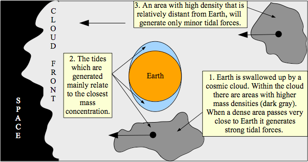
A cosmic cloud may contain variable mass concentrations; i.e. there is no demand for its mass to be evenly spread. On the contrary, it is expected that its mass distribution would be variable (with dense areas and sparse areas). Just as a storm front is not composed from one single cloud, but from the grouping of hundreds or thousands of separate clouds, so may a cosmic cloud be composed of many sub-clouds (see the following satellite image).
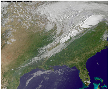
Just as a storm front is not composed from one single cloud, but from the grouping of hundreds or thousands of separate clouds, so may a cosmic cloud be composed from many sub-clouds. In this satellite image we can see a "cold front" (a front of storm clouds), which covers vast areas in eastern U.S.A. This front (which is analogue to a cosmic cloud) is constituent from many sub-areas with variable densities.
(Image source: NASA 6 )
Cosmic clouds may contain quantities of mass, greater than that of any star. There are cosmic clouds that contain so much mass that entire star constellations (with many planetary systems) are formed from them. A dense cloud that passes very close to Earth (or even swallows Earth up) may generate tidal forces just like a rigid body (like an asteroid, comet or planet). In the previous chapter I negated the explanation of the Biblical flood as an extreme oceanic tide mainly because that scenario does not satisfy the demand of the third stage of the flood (the calm stage). However, the same force that may generate an extreme oceanic tide may also have additional effects.
In order to understand the mighty power of tidal forces, let us take off to one of Jupiter's moons, which has drawn a lot of the astrophysicists' and geophysicists' attention in recent years: Io (see the following picture).
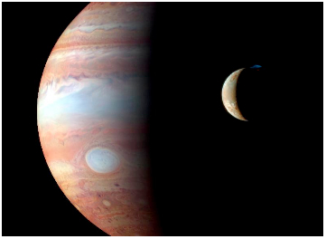
A picture of Io in front of Jupiter. On Io's upper side we can see a blue light. This light is the product of a massive volcanic eruption.
(Image source: NASA 7 )
As of January 2012, Jupiter has 67 known moons8. The moon Io draws the scientists' attention since unusual, extreme and prolonged volcanic activity is taking place there. This activity is related to the special gravitational conditions to which Io is subjected. Io's orbit wobbles between the moons Europa and Ganymede. The gravitational force applied on Io by these moons, together with Jupiter's gravitational force, generate intense tidal forces upon Io. So intense are the tidal forces that they manage to lift Io's crust 100 meters (328 feet) at high tide! These extreme tides generate internal friction and heat, which melt down parts of the moon's mantle. Therefore, Io is abundant with active volcanoes and they erupt very often9. Despite the fact that Io is constantly subjected to extreme tidal forces, its crust does not melt. According to recent estimations, the crust remains solid and its depth reaches dozens of kilometers (or miles). The tidal forces on Io do not act merely upon its surface, but also deep in its mantle, where they generate unusual inner processes.
What will happen to Earth if it would be subjected to such extreme tidal forces? Could a similar process trigger the release of water from Earth's interior? In order to understand the answer we must first calculate how much water is really demanded in order to satisfy the Biblical description of the flood. Then, we should find out where (and in what state) the waters of the great deep exist.
1 Fortney, Jonathan J.; Nettelmann, Nadine (May 2010), The Interior Structure, Composition, and Evolution of Giant Planets,Space Science Reviews 152 (1-4): 423-447, arXiv:0912.0533, Bibcode2010SSRv..152..423F,doi: 10.1007/s11214-009-9582-x
2 Saturn . Encyclopedia Britannica. Encyclopedia Britannica Online. Encyclopedia Britannica Inc., 2012. Web. 04 Dec. 2012 < http://www.britannica.com/EBchecked/topic/525169/Saturn/54278/Basic-astronomical- data >.
3 Saturn . Encyclopedia Britannica. Encyclopedia Britannica Online. Encyclopedia Britannica Inc., 2012. Web. 04 Dec. 2012 < http://www.britannica.com/EBchecked/topic/525169/Saturn/54280/The-interior >.
5 Fleming, Kevin, Paul Johnston, Dan Zwartz, Yusuke Yokoyama, Kurt Lambeck and John Chappell (1998).Refining the eustatic sea-level curve since the Last Glacial Maximum using far- and intermediate-field sites.Earth and Planetary Science Letters 163 (1-4): 327-342.doi: 10.1016/S0012-821X(98)00198-8
7 NASA/Johns Hopkins University Applied Physics Laboratory/Southwest Research Institute/Goddard Space Flight Center.
8 The Jupiter Satellite Page , Department Of Terrestrial Magnetism, Carnegie Institution For Science ht tp://www.dtm.ciw.edu/users/sheppard/satellites/
9 Rosaly MC Lopes (2006). Io: The Volcanic Moon. In Lucy-Ann McFadden, Paul R. Weissman, Torrence V. Johnson.Encyclopedia of the Solar System. Academic Press. pp. 419-431.ISBN978-0-12-088589- 3.
7. How much water?
In the previous chapter I explained why most of the flood's water originated from "the great deep" rather than from Space. I assumed a "working assumption" that the necessary quantities of water, which are needed to satisfy the Biblical flood do indeed exist in the depths of Earth. Before we address the question "where is the water?". We should first estimate how much water is actually needed.
In chapter 2, I concluded that according to the Biblical scenario the flood was global and the tops of all the lofty mountains in the entire world were covered with water up to 15 cubits (around 7.5 meters or 25 feet) above the top of the highest mountain. Today the highest mountain is Everest. Its height is 8,848 meters (29,028 feet) above sea level. However, if the flood originated from intense tidal forces then it is unlikely to assume that the water's level actually reached the top of the Everest. I will explain why immediately.
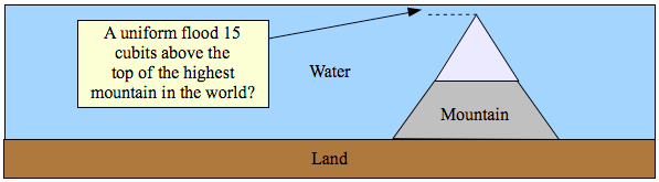
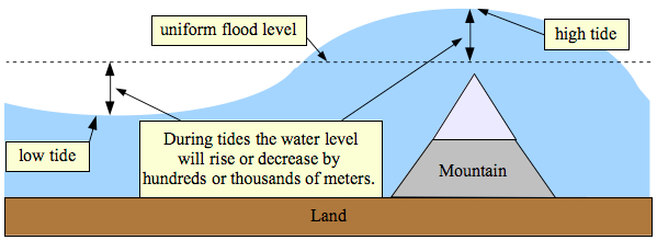
Let us presume for the sake of this discussion, that the Earth was indeed uniformly flooded to a level 15 cubits above the top of the highest mountain (see previous illustration). In the previous chapter I concluded that the flood resulted from extreme tidal forces. These tidal forces somehow caused the waters of the great deep to burst upwards. They may have also caused extreme land tides as in the case of Jupiter's moon Io. It seems logical to assume that such intense tidal forces also caused massive tides in the oceans. While they were in effect, these tides may have lifted the sea hundreds or even thousands of meters (or feet). Their duration was very short. Like Lunar tides, they lasted only several hours. If the uniform level of the flood had been 15 cubits (around 7.5 meters or 25 feet) above the highest mountain top, then during the tide the mountain's top would have been covered by hundreds or thousands of meters (or feet) of water (see the next illustration). This scenario contradicts the Bible. According to the Bible, the maximum covering of the highest mountain top was no more than 15 cubits at the peak of the flood (Genesis 7: 19-20). Hence:
Conclusion: The level of the flood (without the effect of high tides) was hundreds or even thousands of meters (or feet) lower than the highest mountain's top.
A uniform flood scenario 15 cubits above the highest mountain contradicts the Bible, because it follows that the highest mountain was covered by hundreds or even thousands of meters (or feet) of water during the high tides.
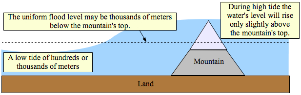
The scenario that fits the Biblical description: The uniform flood level was at some intermediate value, hundreds or even thousands of meters (or feet) below the highest mountain's top, but high enough to enable its covering at the peak of the highest tide.
In this context it is important to mention that the intensities of the high tides do not depend merely on the intensities of the tidal forces, but also on the local topography. For example, local tides may hold values up to ten times greater than those of the tides in adjacent open seas. According to the Guinness Book of World Records (1975), the highest recorded tide occurred in the Bay of Funday, Nova Scotia, Canada. Its height reached 14.5 meters (47 feet). The typical tide in the adjacent ocean is no more than a meter (3.3 feet)! A similar phenomena is well known from tsunamis. Ships and boats, which happen to be in the open sea (where depths exceed 180 meters) do not feel the tsunami, since its height does not exceed a meter (3.3 feet). But as the tsunami gets pushed towards the land it may rise 10 meters or more1. The following map and illustration will demonstrate and explain these phenomena.
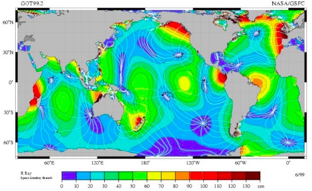
The above is a global map of the typical tides. It can be seen that the high tides in the oceans do not usually exceed 70 centimeters (28 inches). Higher tides are formed only near the coasts of continents or islands and result from their local topography. The local effects can be so sharp that tides may rise more than 10 meters (33 feet)!
(Source: R.Ray NASA)2
When waves propagate from deep to shallow waters and toward the land itself, friction with the ground causes their velocity to decrease. Hence the waves are shortened and their mass is pushed upwards. In principle, this is the reason why local tides may be up to 10 times higher than the typical ocean tides. It is also the reason why tsunami waves, which are negligible in deep waters, may rise by 10 meters (33 feet) or more as they approach the land.
(Picture's creator: Lachaume )3
These given examples merely refer to phenomena, in which the tides or tsunamis do not exceed one meter (3.33 foot) in the open sea. If a tidal force, which raises the ocean level by less than one meter, can cause a local tide of 14.5 meters (47 feet) and if a tsunami that is merely one meter (3.33 feet) can rise by more than 10 meters (33 feet) as it reaches land, what local phenomena might we expect from ocean tides that reach hundreds or thousands of meters? This question demands further research, which is beyond my present capabilities. I would be glad to receive help. Anyway, based on these examples I claim that there is actually no need to demand that the maximum peak of the highest tide reached the top of the highest mountain. The actual flood level, including the level of the highest tide itself, could have been thousands of meters (or feet) beneath the mountain's top, but due to the mountain's local topography the water was pushed over its top for a very short while at the peak of the highest tide.
A strengthening of the whole scenario can be found when we reexamine the Biblical description of the flood, but here we will have to use information that was lost in the translations:
"And the waters returned from off the earth continually: and after the end of the hundred and fifty days the waters were abated."
(Genesis 8: 3, King James' translation)
The Hebrew expression that was translated in the first part of this verse as "...the waters returned from off the earth continuously" can also be translated as "the waters went back and forth". Let us rewrite the verse in its "proper" translation:
"And the waters went back and forth: and after the end of the hundred and fifty days the waters were abated."
(Genesis 8: 3, the "proper" translation)
Until now it may have seemed strange to accept that the water went back and forth. Hence, even the traditional rabbinical commentaries disregarded this possibility. However, my proposed translation is actually straightforward. This is why several rabbis that have previewed this book immediately accepted it. In the context of my theory, this translation suddenly becomes physically clear. The waters "prevailed" on the earth for 150 days. Within this period the waters went back and forth due to intense high and low tides. Mountain tops were repeatedly covered and revealed. Only after 150 days, at the beginning of stage 3, were the waters abated.
I have already concluded that the water level could not have exceeded the height of the highest mountain (Mount Everest?). So what was the actual water level? As we know, Noah's ark is said to have landed on Mount Ararat. The summit of Mount Ararat towers 5,137 meters (16,853 feet) above sea level. Should it be concluded from this data that the level of the flood was necessarily higher than Mount Ararat or should it rather be concluded that the ark rested upon Mount Ararat during one of the tides? If we wish to use the Bible in order to answer this question, we will have to dive deeply into one of the greatest rabbinical disputes. A dispute between the commentaries of the most venerable rabbis Rashi, Ibn Ezra and Ramban...
The dispute originates from the following verses:
"And the waters returned from off the earth continually: and after the end of the hundred and fifty days the waters were abated. And the ark rested in the seventh month, on the seventeenth day of the month, upon the mountains of Ararat."
(Genesis 8: 3-4, King James' translation)
It is explicitly written that the ark rested upon Mount Ararat "in the seventh month, on the seventeenth day of the month". As we know (from Genesis 7:11) the flood began "in the second month, the seventeenth day of the month". The relevant calendar in this context is of course the ancient Hebrew calendar. It begins with the month "Tishri", which falls within September-October. The commentaries agree that the flood began on the 17th of the second month in relation to the ancient calendar. But Rashi notes that the date, in which Noah's ark rested upon Mount Ararat, does not relate to the calendar, but to the day in which the rains stopped. According to Rashi, the rains stopped on the 40th day of the flood (at the end of stage 1), while the waters continued to rise from the great deep until day 150. Rashi did not explain why it is written that "the rain from heaven was restrained" (Genesis 8: 2) only on the 150th day. Therefore, Ibn Ezra disputed Rashi and explained that the rain after the 40th day was not continuous, but it didn't stop completely until the 150th day.
The following commentaries relate to the dates according to the Hebrew calendar. The Hebrew calendar is a lunar calendar, but unlike the Muslim calendar it is calibrated with the solar calendar once in 3-4 years. Therefore, its months can be correlated with the Gregorian calendar (±2 weeks) according to the following table:
-
Month number
Hebrew calendar
Gregorian calendar
1
Tishri
midSeptember-midOctober
2
Marheshvan
midOctober-midNovember
3
Kislev
midNovember-midDecember
4
Tevet
midDecember-midJanuary
5
Shvat
midJanuary-midFebruary
6
Adar
midFebruary-midMarch
7
Nisan
midMarch-midApril
8
Iyyar
midApril-midMay
9
Sivan
midMay-midJune
10
Tammuz
midJune-midJuly
11
Av
midJuly-midAugust
12
Elul
midAugust-midSeptember
According to Rashi, the ark did not rest upon Mount Ararat on the seventh month of the year, but seven months after the rains stopped; i.e. seven months after the 40th day of the flood. In accordance, Rashi calculated that the ark rested upon Mount Ararat on the 9th month of the calendar (the month of "Sivan") and so he wrote: "'in the seventh month ', Sivan, and it is seventh from the month of Kislev, in which the rains stopped".
Ibn Ezra did dispute Rashi's calculation, but did not supply any alternative date and summarized his opinion in the following manner: " It is possible to speak at length about the resting of the ark, but there is no point to it, since it will neither help us nor save us".
On the other hand, Ramban found this issue important enough to devote an extensive explanation of his concept. The explanation of Ramban will be most important and crucial for our understanding of the physical scenario. Ramban noted that the main problem in Rashi's commentaries originated from his misunderstanding of the rate in which the water-level decreased. He claimed that the rate of the decrease must logically match the date, in which the mountain tops were revealed:
"And the waters decreased continually until the tenth month: in the tenth month, on the first day of the month, were the tops of the mountains seen."
(Genesis 8: 5, King James' translation)
Rashi claimed that the mountain tops were seen in the month of "Av", in other words 10 months after the beginning of the flood. Not in the tenth month of the calendar and not even ten months after the rain stopped (according to his interpretation). And so he wrote:
"'...in the tenth month, on the first day of the month '. It is Av, which is the tenth month to the beginning of the flood. And the waters were high above the mountains 15 cubits. And the water decreased from the first of the month of Sivan until the first of the month of Av 15 cubits for 60 days; i.e. one cubit for every 4 days. Hence it follows that until the 17th of Sivan (the day in which the ark rested) the water decreased only 4 cubits. This means that the bottom of the ark was submerged 11 cubits (around 5.5 meters or 18 feet) beneath the water and above the mountain tops. "
In other words, according to Rashi the rate in which the water decreased during the 60 days of the 9th -10th months of the calendar was very low. Only one cubit for every 4 days. Therefore, although the ark rested upon Mount Ararat already on the 17th of Sivan, the top of Mount Ararat was revealed only a month and a half later. The bottom of the ark was submerged 11 cubits under the water while the ark floated (just like the bottom of any ship). From the moment that the ark rested upon the top of Mount Ararat until the summit was exposed the water level merely decreased by these 11 cubits. This process took a month and a half.
Rashi lived during the 11th century (CE) in France and as the rest of the Europeans in his era, he probably had never heard about the Himalayas. Even if he did hear about its existence he had no way of determining the height of the Everest in relation to that of Mount Ararat. Today we have knowledge of important data, which the medieval commentators did not know. The Himalayas are several kilometers (1-2 miles) higher than Mount Ararat. The top of the Everest is 8,848 meters (29,028 feet) and the top of Mount Ararat is 5,137 meters (16,854 feet) above sea level. On the other hand, Rashi, Ibn Ezra and Ramban all agreed that the flood was global and that at its peak it covered the tops of all the lofty mountains. So it follows that we must conclude that even the Everest was covered during the peak of the highest tide. From Rashi's commentaries it seems that he believed Mount Ararat to be the highest mountain in the world.
Mount Ararat is in fact the highest mountain in Eurasia west from Hindu-Kush. According to Rashi the water level was at its peak 15 cubits above Mount Ararat and therefore merely decreased by 4 cubits during the 17 days that passed until the ark rested. If Rashi would have determined that the water level had reached 15 cubits above the Everest, he couldn't have reached such conclusions. It is also evident that Rashi did not take into account the effects of the tidal forces which I describe in this research. In my scenario, the variations in the water levels were rapid (hundreds and maybe thousands of meters within several hours).
Ramban lived in Spain in the 13th century (CE), some 200 years after Rashi. Like Rashi, he too had no topographic knowledge of the Everest and Mount Ararat. Neither did he have any clear knowledge regarding the physics of tidal forces. However, he did determine the problems in Rashi's calculations, reexamined them and reached his own stunning conclusions:
"Rashi wrote that the bottom of the ark was submerged by 11 cubits, in correlation with his calculations. That is also the case in Genesis Raba (32: 7). But since Rashi is painstaking in many places with the rabbinical commentaries and bothers to interpret them, let us also do the same, because the Torah has 70 faces and there are many disputes among the sages."
"And I say that Rashi's calculation does not properly interpret what is written. Because if we interpret that the ark rested on the seventh month from the day in which the rain stopped, instead of relating to the seventh month of the calendar as we did in the case of the second month in the beginning of the flood (Genesis 7: 11) and as we also do at the end of the flood (Genesis 8: 14), how could he suddenly relate the tenth month to a different count?"
"And his evidence that the bottom of the ark was submerged, because in this manner he calculated an even decrease in the water's level for every day, one cubit for every 4 days, this is not evidence. It is well known that a great river may initially decrease one cubit of water in 4 days and then 4 cubits of water in one day. According to Rashi, the mountain top was seen on the first of the month of Av (the 11th month) and on the first of Tishri (the first month) the waters were dried up from the earth. Did all the volume of water to the height of the mountains dry up in merely 60 days? Furthermore, according to Rashi, Noah sent the dove on the seventeenth of Elul (the 12th month) and the waters still covered most of the land and the trees were submerged. Did all the water dry up in merely 12 days?..."
"And what may seem to be straightforward is that 150 days in which the waters prevailed (Genesis 7: 24) will include the 40 days of rain, because most of the increase should have been in those days. And it turns out that the waters began to decrease on the 17th of Nissan (the 7th month) and the ark rested upon Mount Ararat 30 days later on the 17th of Eyar (the 8th month), which was the seventh month of the flood. And after 73 days, on the first of Av (the 11th month), which is the tenth month of the flood, the mountain tops were revealed."
"And I claim, that 150 days were from the 17th of the second month until the 17th of the 7th month and on that same day the ark rested, because at that same day God made a wind to pass over the Earth all night long and he dried up the waters and they were extremely decreased and then the ark rested. And the evidence is that it is not written in the Bible that "the waters decreased at this month at this day and continued to decrease until the seventh month and then the ark rested" like it was written when the mountain tops were revealed. It was not written so because the ark rested upon Mount Ararat on the same day of the extreme decrease."
"And the order of this issue is, that on the day when the rain began the windows of heaven and the fountains of the great deep were opened. And the rain poured down for 40 days, in which the waters prevailed 15 cubits above the mountain tops. And the rain stopped at the end of 40 days but the fountains of the great deep as well as the windows of heaven remained open. And the air was extremely humid and all the earth was full of water that could never dry up. And the water continued to prevail until 150 days, from the beginning of the flood, had passed. Then God made an extremely strong wind to pass in the heaven and on the earth and the fountains of the great deep were closed and the waters returned to the great deep to their initial location. And the air dried up extremely and the water that was upon the land dried up in the strong wind. And so the water's level decreased extremely on that day and the ark, which was submerged 23 cubits in the water, rested upon Mount Ararat. And 73 days later, on the first day of the tenth month, which is the month of Tammuz, the mountain tops were seen. And 40 days later, on the tenth of the 12th month, Noah opened the window of the ark. And 3 weeks later the dove departed from it. And 30 days later he removed the cover of the ark."
It can be seen how Ramban concluded that the 150 days, in which the waters prevailed upon the earth, included the initial 40 days of rain. Ramban also explains that the date, in which the ark rested upon Mount Ararat is relative to the calendar and not to the beginning of the flood. Hence it follows that the ark rested upon Mount Ararat immediately when the initial 150 days of the flood came to an end. At that same day, a mysterious wind passed upon the entire planet. The wind was extremely strong and somehow related to an extreme and immediate decrease in the water's level. As Ramban wrote, "the ark rested upon Mount Ararat on the same day of the extreme decrease." Such a rapid decrease in the water's level strongly connects Ramban's scenario with our tidal scenario. But how does the wind relate to our scenario?
Winds are formed by atmospheric pressure differences. Low pressure areas in the atmosphere suck in air from surrounding areas. We feel the motion of the air from high to low pressure areas as "wind". The usual cause for the creation of low pressure areas is the sun-related heating of the air. But during the Biblical flood an additional and most powerful cause affected the atmosphere.
Tides occur routinely not only in the sea, but also in the atmosphere. The routine Lunar atmospheric tides cause negligible pressure differences (only 0.01% in relation to ambient pressure4). But extreme tidal forces should cause much greater pressure differences and therefore they should also generate winds. Let us name these winds as "Tidal Winds". The tidal winds should have blown upon the entire planet as long as Earth was subjected to extreme tidal forces. What is so unique with the 150th day of the flood? The day in which an extreme wind blew upon the entire planet and immediately after that the fountains of the great deep and the windows of heaven were closed. Let us examine what happened to Earth on the day it separated from the cosmic cloud.
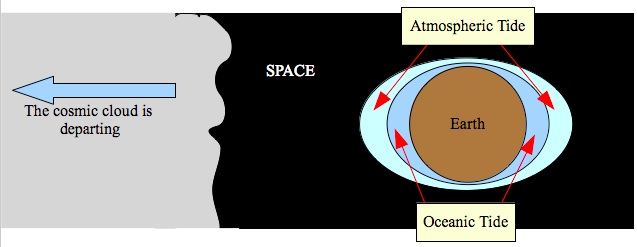
On the day when the cosmic cloud departed from Earth, all its mass suddenly pulled in a single direction, hence generating the most extreme tidal forces. The cloud gave Earth one great but last squeeze and then quickly released it, since the tidal forces decay rapidly as the distance grows.
As long as Earth was surrounded by the cosmic cloud, it was not practically influenced by the tidal forces from most of the cloud's portions, because forces in opposite directions canceled each other out. The main influence was from dense areas of the cloud, which passed very close to Earth. But on the day when Earth separated from the cloud all the gravitational forces from all the portions of the cloud pulled in the same general direction. They all summed up together instead of canceling out one another out. Therefore, on this day Earth must have experienced the greatest oceanic and atmospheric tides. This is the 150 th day. This is the reason why such intense winds blew upon the entire planet on that single day.
However, tidal forces quickly decline as the distance grows (gravitational forces are proportional to the inverse square of the distance). Therefore, the strong tide quickly declines too. At this stage the cosmic cloud released its grip. The extreme tidal forces came to an end and Earth's systems aimed to rebalance. The sea that had rapidly moved back and forth during 150 days quickly calmed down and the water level stood at last on its real and uniform flood level. From here on the water level gradually and calmly decreased. The cosmic cloud initially opened the windows of heaven and the fountains of the great deep. Now that the cloud had departed from Earth, both the windows of heaven and the fountains of the great deep had closed back.
It now follows that the real flood level must have been lower than Ararat's summit, but higher than the tops of other mountains in the same region. The extreme decrease in the water's level on the 150th day together with the data that the ark rested on Mount Ararat on that same day, implies that the ark was elevated upon Mount Ararat during the extreme high tide and rested upon it as the tide released its grip. This means that the top of Mount Ararat was already exposed by the end of the 150th day. The mountain tops that were revealed 73 days later were those of the surrounding mountains. This is a new insight that is based on the commentaries of Ramban. The credit for this interpretation belongs to Uriel Farjon. The flood level at the end of the 150th day was lower than Mount Ararat, but it must have been higher than the surrounding mountain tops, which were still submerged.
It will now make sense to check the heights of the surrounding mountains:

(Map creator: Captain Blood5)
When we examine the physical map of Turkey and its region we discover many high mountain ranges in the surrounding area of Mount Ararat. All the white areas in the map above represent mountain ranges higher than 2,500 meters (8,200 feet). I have marked Mount Ararat as a red triangle. The orange triangles represent all the mountains in a 300 kilometer (186 miles) radius from Mount Ararat, which tower above 3,600 meters (11,811 feet). The highest among them is Mount Suphan Dagi, which towers above the northern side of Lake Van to an altitude of "merely" 4,020 meters (13,779 feet). In the range of 3,600-4,000 meters (11,811-13,123 foot) there are 4 additional mountains besides Suphan Dagi and in the range of 2,600-3,600 meters (8,530-11,811 feet) there are dozens of mountain peaks.
It is evident that the difference between the altitude of Mount Ararat and that of Suphan Dagi is greater than a kilometer (0.62 miles), around 1.5 kilometers (0.93 miles) to the following mountains and around 2 kilometers (1.24 miles) to dozens of other peaks in the region. Notice that the Bible refers to the day in which the mountain tops (in plural not single) were seen. This means that we should not refer merely to the top of Sufan Dagi, but to the 4 other summits as well and maybe even to summits lower than 3,600 meters (11,811 foot). Evaluating this data leads to the conclusion that the water on the day when the mountain tops were seen was at some level within the altitude range of 3,000-4,000 meters (9,842-13,123 feet). These conclusions are based on the assumption that the topography of the region has not varied significantly since the Biblical flood. I am not at all sure that this assumption is true, but it gives something to work with.
Throughout this chapter we are trying to estimate the quantity of water that is needed to satisfy the conditions of the Biblical flood. Hence we tried to estimate the maximum level of the flood. While doing so we neutralized the direct effects of high and low tides on the water's level. As mentioned, the waters were calm during the third stage of the flood (after the 150th day). Calm water cannot exist when huge tides wash the planet. Therefore, the water's level along stage 3 should indeed reflect the real flood level and not the levels of short term tides. From the topographic data of Mount Ararat and its region we have now reached an "upper boundary" and a "lower boundary" for the maximum level of the flood. The upper boundary is the altitude of Mount Ararat (5,137 meters, 16,854 feet). The lower boundary is the altitude of dozens of summits in the region: 3,000 meters or 9,842 feet. Therefore:
Conclusion: The real flood level should have had some value within the altitude range of 3,000-5,137 meters (9,842-16,854 feet).
From this data we can derive upper and lower boundaries for the necessary quantity of water. The formula for this calculation is very simple. Let us note with 'R' the radius of Earth and with 'h' the flood level. Then:
[volume of a ball with radius R+h] - [volume of a ball with radius R] = [volume of flood water]
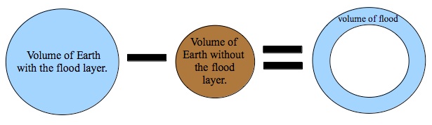
In order to calculate the quantity of water in the flood layer (blue stripe) it is only necessary to calculate the volume of the external ball (representing the volume of Earth with the flood layer) and subtract the volume of the inner ball (representing the volume of Earth without the flood layer).
-
Earth's radius (noted as R) is 6,378 kilometers (3,963 miles) in the equator.
-
The upper boundary for the flood level is 5,137 meters (16,856 feet): the altitude of Mount Ararat.
-
The lower boundary for the flood layer is 3,000 meters (9,842 feet): the altitude of dozens of mountains in Ararat's region.
-
The quantity of water that is estimated in the oceans today is 1.33 billion cubic kilometers 6 (0.24 billion cubic miles). The oceans waters constitute 97% of the water in the hydrosphere. We will call this quantity an " oceanfold " and we will estimate the necessary quantity of water units of oceanfolds.
The calculation shows that:
Conclusion: The necessary additional water quantity for satisfying the conditions of the Biblical flood is smaller than 1.98 and greater than 1.15 oceanfolds.
-
The water quantity which we have just calculated is still exaggerated. In fact a more accurate calculation should take into account the average altitude of the continents and subtract their volume from the water's volume. In addition, the water that came out from the great deep may have caused Earth's radius to slightly decrease. Therefore the radius for the accurate calculation may be a bit smaller. These considerations will only decrease the flood's volume even more.
Just before I finish this chapter, I wish to note that I tend to believe that the altitude of the highest mountain in the world was significantly lower than it is today and I am not at all sure that Mount Everest was the highest mountain back then too. As we shall see in the following chapters, we can likely presume that the same forces, which caused the flood also amplified tectonic activities, and specifically pushed the Himalayas further up.
Now that we know how much water is needed in order to satisfy the Biblical flood, we can use the most recent geophysical and geochemical data in order to prove or disprove the "working assumption" from chapter 6. Is there really enough water in the great depths of Earth?
1 Tsunami . JetStream. Online School For Wheather. National Weather Service. NOAA. http://www.srh.noaa.gov/jetstream/tsunami/tsunami_faq.htm
4 Rashid Akmaev. Does the Moon have a tidal effect on the atmosphere as well as the oceans? Scientific American. August 7, 2006. http://www.scientificamerican.com/article.cfm?id=does-the-moon-have-a-tida
6 Matthew A. Charette and Walter H.F. Smith. The Volume of Earth's Ocean. Oceanography. Volume 23. Number 2. http://www.tos.org/oceanography/issues/issue_archive/issue_pdfs/23_2/23-2_charette.pdf
8. Where is the water?
As aforesaid, the quantity of the groundwater is negligible in comparison to that of the oceans and it certainly cannot satisfy the Biblical flood. Therefore, in order to find the waters of the flood we must go further and deeper beyond Earth's crust. We must reexamine the geological knowledge regarding our planet's interior.
The structure of Earth
(Picture creator: Surachit)1
Earth's interior is composed from a "Core", a "Mantle" and a "Crust":
The core is composed mainly of iron and nickel and its width is around 3,500 kilometers (2,175 miles). It is divided into an "Inner Core" (around 1,220 kilometers or 758 miles wide) and an "Outer Core" (around 2,266 kilometers or 1,408 miles wide). There is strong evidence that the inner core is solid and the outer core is viscous-liquid2. Honey is a well known example for a viscous-liquid, when it is at room temperature. Like honey, a viscous-liquid has a thick and sticky consistency between solid and liquid. On the other hand, water (at room temperature) is an example of diluted liquid. It flows easily and thus cannot be regarded as a viscous liquid.
The Mantle is composed mainly from magnesium enriched silicate rocks. It is divided into a "Lower Mantle" (around 2,230 kilometers or 1,386 miles wide) and an "Upper Mantle" (around 600 kilometers or 373 miles wide). The mantle rocks are mainly solid, but do have some viscosity and elasticity, which enables slow movement throughout time. The mantle also contains limited areas of "Magma" 3. Magma is a term that is used to describe any molten or partially molten mixture of rocks. In Greek the verbal meaning of "magma" is merely "mixture". The lava that flows out of volcanoes is a type of magma.
The Crust is the solid and rigid rock layer that we live and step upon. It is mainly composed of silicon and aluminum oxides with lower concentrations of calcium, sodium, iron and magnesium oxides. Its width varies from dozens of kilometers (or miles) in the continental crust to several kilometers (or miles) in the oceanic crust.
According to the theory that is accepted today, Earth was formed around 4.5 billion years ago 4 from the same nebula (a type of cosmic cloud) that created the entire solar system. Material within the solar nebula gathered together first by chemical attraction and later on by gravitational pull. The sun and its planets began to form into a shape. As Earth grew and gained mass its gravity became stronger and it was able to draw more and more material from the surrounding nebula. This process involved many violent collisions with other forming asteroids and "protoplanets". Most of the energy from these collisions was transformed into heat. The intense heat melted most of the material upon the forming planet. Therefore, ancient Earth was in fact a burning ball of magma. In such conditions, when most of the material was liquid, the heavier materials were free to sink towards the center of the Earth while the lighter materials were free to float upon them. Therefore, based upon their specific gravities, the separation of the materials to Core, Mantle and Crust took place. Water and gas, which was released from the magma floated above the crust and formed Earth's ancient oceans and atmosphere.
The Crust itself is divided into "Continental Crust" and "Oceanic Crust". The continental crust is composed mainly from si licon-aluminum based rocks and is therefore referred to as "Sial". On the other hand, the oceanic crust is merely a solidification of mantle rocks and is similarly composed from the mantle's elements, mainly silicon-magnesium based rocks. Therefore the oceanic crust is referred to as "Sima". The specific gravity of aluminum is less than that of magnesium. Hence, the continents are in fact lighter than the mantle and literally float upon it just like a ship floats upon the water. Earth does not contain enough sial to supply a continuous cover of the whole mantle, but merely to create continental blocks.
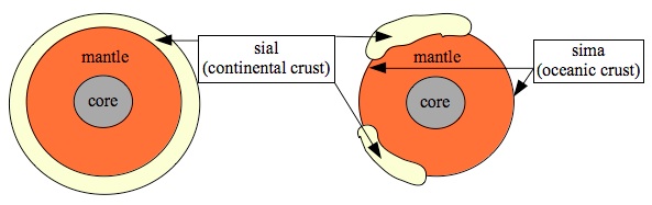
If Earth had enough sial, then we would have received another"mantle" above the existing one (left illustration). Instead, the existing sial floats in separate blocks upon the mantle and constitutes the continents (right illustration).
After the Sun, Earth and other planets had drawn most of the nebula's material to themselves, the rate of violent collisions with other celestial bodies decreased. Earth radiated its excess heat into Space and cooled down. The most outer layers began to solidify. However, Earth remained with an internal heat source, which prevented its total solidification. Heavy radioactive elements had sunk into its core. The radioactive radiation emitted from these elements still produces substantial heat and it is considered as Earth's main internal heat source.
Nevertheless, Earth did cool down enough to enable solidification of rocks far beneath its crust. The most upper layer of the mantle had totally solidified 50-200 kilometers (31-124 miles) deep, depending on the specific region. This most upper layer of the mantle practically stuck to the bottom of the crust. Therefore, a special term has been defined in order to describe the unified crust-most upper mantle layer: the "Lithosphere". "Lithos" stand for "rock" in Greek. Hence, "lithosphere" stands for the "rocky sphere".
As recalled, the upper mantle continues around 600 kilometers (373 miles) beneath the crust. The lower portion of the lithosphere, which is beneath the crust, is in fact included in the upper mantle. Within the upper mantle and right beneath the lithosphere there is another internal layer named "Asthenosphere". This layer is characterized by increased viscosity. Due to its high temperature it is not as rigid as the lithosphere. The asthenosphere has increased elasticity, but most geologists still define the phase of its rocks as "solid". Its name was derived from its decreased rigidity: "Asthenos" is "weak" in Greek. The asthenosphere is verbally the "weak sphere". It continues down from the boundary of the lithosphere and it may reach a depth of 700 kilometers (435 miles), but its typical depth is 100-350 kilometers (62-217 miles)5 and its typical width is 100 kilometers (62 miles) 6.
It is well known that the continents drift at a rate of several centimeters (less than an inch) per year. But the continental drift is merely a portion of the general drift of the "Tectonic Plates". The entire lithosphere, both continental and oceanic, is divided into tectonic plates and every one of these plates is drifting upon the asthenosphere beneath it. See the following pictures.
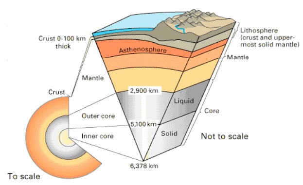
The lithosphere and asthenosphere in relation to Earth's interior. The asthenosphere and the lower part of the lithosphere are both included within the upper mantle.
(picture's source: USGS7)
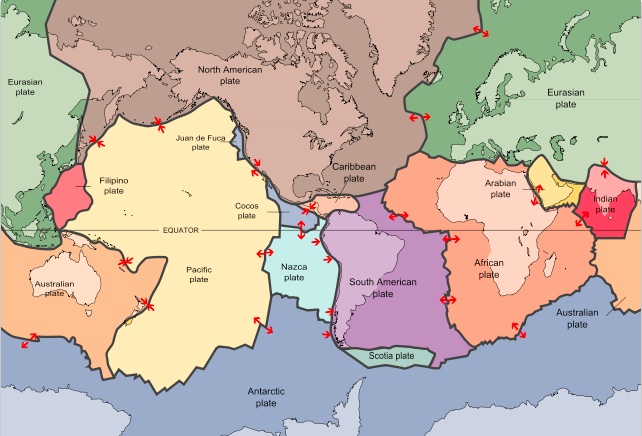
Earth's tectonic plates. The lithosphere of each tectonic plate drifts upon the asthenosphere beneath it according to the directions shown by the red arrows.
(picture's source: USGS)8
It should be understood that the geophysicists, who slowly construct the picture of Earth's internal structure, base their determinations only on indirect evidence. As of today (year 2012), no one has yet drilled beneath the crust. Our knowledge is based most of all on the analysis of "Seismic Waves". "Seismos" means "earthquake" in Greek. Seismic waves are generated from earthquakes. In principle, seismology is similar to ultrasound. Just as we can "see" variations in the densities of our internal organs (or our embryos), we can also "see" variations in Earth's internal structure. In every earthquake vibrations are formed. These vibrations are an analogue to the vibrations generated by an ultrasound transducer. The vibrations pass through Earth's crust, into its mantle and some even cross its core. They are received in different seismic stations all over the planet. By calculating the time differences from the original earthquake until the vibrations are received in the seismic stations, we can derive data regarding the speed of the waves in Earth's different layers. The degree of permeability of each seismic wave into Earth's interior depends on its frequency and amplitude. Waves with different features penetrate different layers and depths. See the following illustration for some further detail.
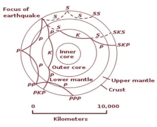
This is a cross section of the whole Earth, showing the complexity of paths of seismic waves.The waves advance from the earthquake's focus. The paths curve because the different rock types found at different depths change the speed at which the waves travel. Solid lines marked P are compressional waves; dashed lines marked S are shear9 waves. S waves do not travel through the core but may be converted to compressional waves (marked K) on entering the core (PKP, SKS). Waves may be reflected at the surface (PP, PPP, SS).
Like the speed of a sound wave, the speed of a seismic wave depends on the density of the material through which it passes. It is therefore indirectly possible to calculate the densities of Earth's different layers. Based on the density of each layer, we may infer its composition. The analysis of additional wave related data, like its "damping" and reflection helps to complete the picture. The damping of a wave is the decrease in its amplitude, which implies how much energy the medium drains from the wave as it passes through it. The reflection of seismic waves is in fact a type of echo. Different materials produce a different echo. With time, as we gather up more seismic data, the resolution of Earth's internal structure becomes sharper.
In between the main layers (crust, mantle and core) and also within the layers themselves there are "transition zones" and " discontinuities". In these layers, substantial differences in the velocity of the seismic waves were discovered. It seems that these layers are less dense than their surroundings. They generate an ongoing discussion amongst geologists. The density decrease may imply partial melting of the material, since solid phases are usually denser than liquid phases. It may imply temperature differences, since cold material is usually denser than hot material. It may also imply differences in the detailed composition of the rocks. Among other claims, it is commonly argued that the existence of the transition and discontinuity zones implies an intensified presence of water in these regions .
The temperature of the mantle and core is hundreds and even thousands of degrees (Celsius or Fahrenheit). Allegedly, it is far beyond the water's boiling temperature. Then how can liquid water exist in the depth of Earth? Isn't the water supposed to boil and escape upwards?
As we go deeper into the Earth the temperature does indeed rise. But the ambient pressure also rises and it rises rapidly. What do I mean by "ambient pressure"? Any one that flies in an airplane or climbs up a mountain feels the decrease of the atmospheric ambient pressure in his ears. When we ascend the ambient pressure decreases and when we descend it increases. The ambient pressure that is applied upon us is equal to the weight of all the material above us, all the way to the edge of the atmosphere. The air's density is very low, therefore only when we ascend or descend hundreds of meters (or feet) we feel the difference upon our body. But in liquids and solids the density is far greater and the difference can be felt even in a depth of one or two meters (3-6 feet). Anyone that dives to the bottom of a pool (in the "deep" water) immediately feels the pressure in his ears.
A water column 10 meters (33 feet) high generates an ambient pressure that equals the ambient pressure generated by the entire atmosphere. Hence, the ambient pressure at a depth of 10 meters (33 feet) is double (atmospheric pressure + water pressure = ambient pressure 10 meters beneath the water). At a depth of 100 meters (328 feet) the ambient pressure is already 11 times greater than the atmospheric pressure. As we know, ground and rocks have greater specific gravities than water. Therefore the ambient pressure within the ground increases even faster. The ambient pressures within the mantle and core are tens of thousands of times greater than the pressure on the ground in which we live.
In very high ambient pressures additional phases exist. We all know about the "solid", "liquid" and "gas" phases. For example we know that if we heat an ice cube the water undergoes a phase transformation from solid to liquid. If we continue to heat the water it will boil and undergo another phase transformation from liquid to gas. But water, like any other material, will not behave in the same manner if it is subjected to very high ambient pressures. Very high ambient pressure does not allow the molecules to depart from each other in a manner that defines the gaseous phase (see illustration).
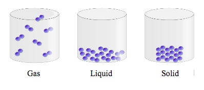
These are normal low-pressure phases. The density of the material sharply drops while it passes from the liquid to the gaseous phase. When the material is subjected to very high ambient pressure, the molecules cannot depart from each other enough to enable the gaseous phase. Instead a new phase named "supercritical liquid" is formed.
(picture creator: Yelod11)
Any material has its own "Critical Point". The critical point is a unique combination of pressure and temperature, from which the material can no longer sustain a gaseous phase. For example, the critical point of water is at an ambient pressure of 218 atmospheres (i.e. a pressure 218 times greater than the atmospheric pressure at sea level) and at a temperature of 374 degrees celsius (705 degrees fahrenheit).This means that water cannot boil under ambient pressures greater than 218 atmospheres 12. This is true for any temperature value at this pressure (see the following graph). Even when the temperature is lower than the critical temperature, ambient pressures higher than the critical pressure do not allow formation of gaseous phases. If in addition the temperature is also above the critical temperature, then the water transforms to a "supercritical fluid" phase. In this phase the water is still liquid, but can penetrate into other materials and dissolve in them as easily as gases do.
When a material is subjected to ambient pressure that is greater than its critical pressure, it cannot transform to a gaseous phase. For example, water cannot boil at pressures greater than 218 atmospheres and it will always remains liquid or solid. If in addition the temperature is also greater than its critical value (374 degrees celsius or 705 degrees fahrenheit), then the water is in a "supercritical fluid" phase. In this phase it is dense like a fluid, but can penetrate into other materials and dissolve into them as if it were a gas.
(Graph's creator: Matthieumarechal13)
In water, the critical pressure is reached at a depth of merely (around) 2,180 meters (7,153 feet). In the crust's ground and rock layers it will even take much less. It can now be understood why the question "why doesn't the water in the depths of Earth boil?" is irrelevant.
It seems that the water in the depths of Earth is not concentrated in underground oceans, but dissolved within the rocks and magma of the mantle and core. The water is dissolved in the magma like salt dissolves in seawater. Solid rocks absorb small concentrations of water within them. It must be understood that a "solid" is not necessarily rigid. A rubber band is solid, but extremely elastic. A sponge is also solid, but very elastic and may absorb great quantities of water. Due to the high temperatures within Earth's interior, the rocks of the mantle are typically more viscous and elastic than "normal" rocks upon the land. However, even normal land rocks may absorb a lot of water. A common example is that of lime stone, that is very permeable. Another well known example is concrete. If water hadn't easily dissolved into concrete, we wouldn't have needed to tar our concrete rooftops. It is well known that someone who doesn't tar his concrete rooftop quickly suffers from dampness. Since Earth's mantle and core have huge volumes, the quantities of water that may be dissolved within them can easily exceed the necessary quantity for the Biblical flood, even if the water's concentration is merely a fraction of a percent.
When I looked for estimations of the quantities of water in Earth's mantle, I found an article from 2005 of Professor Michael E. Wysession and his assistant Jesse F. Lawrence from the Washington University14. Lawrence and Wysession estimated that the rocks of the lower mantle alone contain up to 5 oceanfolds of water, despite the fact that its water concentration is very low (0.05-0.2%). I have not found yet any estimation for the quantity of water in the upper mantle and I will be glad to receive new information.
The volume of the upper mantle is smaller than that of the lower mantle, but its rocks may contain much higher water concentrations. The transition zone between the lower and upper mantle is a natural candidate to containing great quantities of water. Its saturation concentration has been estimated as much as 20 times greater than that of the lower mantle. In other word, the rocks in the transition zone may absorb quantities of water (per volume unit) 20 times greater than those of the lower mantle's rocks15. It is also claimed that the asthenosphere holds very high concentrations of water16. So may the core-mantle boundary contain large quantities of water and even the entire outer core17. Discussions regarding the quantities of water in the mantle and core have been going on throughout the last decade and the whole subject is a very "hot" issue in present geophysical and geochemical research. It seems that these discussions cannot yet (as for 2012) be decided and they will go on for a while. Nevertheless, it is possible to determine with a great deal of certainty, that the total quantity of water, which is held within Earth's interior, is far greater than that of the hydrosphere. As recalled, in order to satisfy the conditions of the Biblical flood we "merely" need a quantity of water that is equal to about 1-2 oceanfolds to be released from the depths of Earth.
Conclusion: Earth does in fact contain a quantity of water that can satisfy the conditions of the Biblical flood.
-
In this conclusion we have now proved our "working assumption" from chapter 6 ("Clues for the real nature of the flood?").
More than everything, what caught my attention in Wysession's and Lawrence's article was the evidence that oceanic water is constantly drawn down deep into the mantle. As recalled, the continents drift (several centimeters or less than an inch per year). In some regions, mainly around the Pacific Ocean, the continental lithosphere "climbs" over the oceanic lithosphere and causes it to bend down (see the next illustration). The oceanic lithosphere slowly descends to the depths of the mantle. Its "signature" is well seen in many seismic tomographies. It seems that the descending oceanic lithosphere begins to melt and decompose only within the lower mantle at a depth of 1,400 kilometers (870 miles). For several decades it was not clear whether the oceanic lithosphere also drags oceanic waters down with it. But in their 2005 article, Wysession and Lawrence revealed a 3-D whole mantle model, based on a most detailed seismic attenuation tomography. The results were far reaching and surprising. All the signs showed that huge quantities of water are dragged down together with the oceanic lithosphere. The water is gradually released from the lithospheric rocks as they descend. When the lithosphere sinks and heats up, its water saturation concentration decreases and it ejects more and more water to the surrounding mantle. The water dissolves into the mantle rocks, which lie above the descending lithosphere and sharply increases their water concentrations. This phenomena creates water anomalies. Wysession and Lawrence estimated the quantity of water in the East Asian water anomaly alone as greater than that of the Arctic Ocean.
When the continental lithosphere drifts against the oceanic lithosphere it bends it down into the asthenosphere (3). Water from the ocean that was absorbed in the oceanic lithosphere is dragged down together with it.
(Source of picture: USGS/USGov modified by Eurico Zimbres)18
Question: If oceanic water is constantly dragged down into the mantle and this process has been going on for billions of years, shouldn't there be a constant decrease in the sea level throughout Earth's history? Shouldn't the oceans have been absorbed into the mantle ages ago?
The existing data shows that the sea level has been relatively stable throughout half a billion years (see the following graph). I have not yet found any record for previous sea levels and I would be glad to receive new data. The known fluctuations in the sea level is merely in scales of several hundreds of meters (or feet) and lacks a clear trend of decrease or increase. It can be fully explained by glacial fluctuations. In other words, at least during the recent 500 million years, the oceans have not lost a substantial quantity of water to the mantle or core. How is this possible?
The table demonstrates the fluctuations of the sea level throughout the last half billion years according to two different evaluation methods (every method is marked by a different color). It can be seen that the fluctuations are in a scale of several hundreds of meters (or feet), totally within the expected glacial fluctuations, and lack a clear trend of decrease or increase.
(Source of picture: Robert A. Rohde, GlobalWarmingArt) 19
It is possible that the rate, in which the water is dragged down is very slow and so is the rate in which the water dissolves into the mantle. Wysession and Lawrence have suggested that the water anomalies that they discovered are about 200 million years old. Another possibility is that a planetary water cycle exists. The conventional water cycle that we study in school merely includes our hydrosphere and atmosphere. In the "planetary" water cycle I wish to say that the general water cycle involves our entire planet. It involves the atmosphere, hydrosphere, crust, mantle and core. I am not the first to claim that against the water that is dragged down into Earth the mantle releases an equal quantity of water through volcanic and related activities. The hypothetical existence of a planetary water cycle has been discussed in many articles and there are efforts to understand it and prove its existence. Until now, this issue has not yet been decided. I would be glad to receive new information from the readers on this issue.
It is important to understand that the existence of a stable planetary water cycle throughout hundreds of millions of years is possible only if a chemical and physical balance between the oceans and Earth's interior is preserved. The assumption is that Earth cannot absorb any more water. If some water is actually dragged down in one location (as in the case of the oceanic descending lithosphere), then an equal quantity of water must be released in a different location. The release of the water probably occurs through volcanic activity. It is known that more than 60% of the volcanic gases are merely composed of steam20, but it is still unclear how much of this quantity originates from the magma itself and how much joins the erupting mass from the surrounding aquifers within the crust.
As recalled, the title of this chapter is "Where is the water?". We have merely received a partial answer for this question. We concluded with a great deal of certainty, that Earth does contain quantities of water, which can easily satisfy the necessary quantities for the Biblical flood. These water quantities are present in the mantle and maybe even in the core. We have understood that the water does not fill oceans in Earth's interior, but is dissolved in the mantle's and core's rocks and magma. However these answers merely supply us with general and inaccurate data. In order to sharpen our understanding we must further research the idea of the "planetary water cycle". We must try to understand how it works, in what areas of the mantle is the water locked and why? The better we understand the planetary water cycle, the better we will understand how "the waters of the great deep" were suddenly released when the balance was disrupted and then returned to the great deep when the disruption had passed.
2 Gillan, Michael J.; De Wijs, Gilles A.; Kresse, Georg; Vo?adlo, Lidunka; Dobson, David; Alf?, Dario; Price, Geoffrey D. (1998). "The viscosity of liquid iron at the physical conditions of the Earth's core" . Nature 392 (6678): 805. Bibcode1998Natur.392..805D. doi:10.1038/33905.
3 Earth's Interior. The Nevada Seismological Laboratory. University of Nevada. Reno. http://crack.seismo.unr.edu/ftp/pub/louie/class/100/interior.html
4 "Age of the Earth" . U.S. Geological Survey. 1997. Archived from the original on 23 December 2005. Retrieved 2006-01-10.
5 Asthenosphere . Encyclopedia Britannica. Encyclopedia Britannica Online. Encyclopedia Britannica Inc., 2012. Web. 21 Nov. 2012 < http://www.britannica.com/EBchecked/topic/39770/asthenosphere>.
6 Ms. Sofia Valleley. Keeping the Earth’s plates oiled. 1. June 2007. European Science Foundation. http://www.esf.org/research-areas/life-earth-and-environmental-sciences/news/ext-news-singleview/article/keeping-the-earths-plates-oiled-296.html
9 Shear is the change of shape, without change of volume, of a layer of the substance, produced by a pair of equal forces acting in opposite directions along the two faces of the layer. If the medium is elastic, the layer will resume its original shape after shear, adjacent layers will undergo shear, and the shifting will be propagated as a wave. "shear wave". Encyclopedia Britannica. Encyclopedia Britannica Online. Encyclopedia Britannica Inc., 2012. Web. 31 Dec. 2012 < http://www.britannica.com/EBchecked/topic/539300/shear-wave>.
12 International Association for the Properties of Water and Steam, 2007. http://www.iapws.org/relguide/TransD2O-2007.pdf
14 Jesse F. Lawrence. Michael E. Wysession. Seismic Evidence for Subduction-Transported Water in the Lower Mantle. 2005_MONOGRAPH. http://epsc.wustl.edu/seismology/michael/web/lawrence_and_wysession_2005_MONOGRAPH.pdf
15 Bercovici, E., and S.-I. Karato (2003), Whole-mantle convection and the transition –zone water filter, Nature, 425, 39-44, 2003.
16 Ms. Sofia Valleley. Keeping the Earth’s plates oiled. 1. June 2007. European Science Foundation. http://www.esf.org/research-areas/life-earth-and-environmental-sciences/news/ext-news-singleview/article/keeping-the-earths-plates-oiled-296.html
17 Hidenori Terasaki, Eiji Ohtani, Takeshi Sakai, Seiji Kamada, Hidetoshi Asanuma, Yuki Shibazaki, Naohisa Hirao, Nagayoshi Sata, Yasuo Ohishi, Tatsuya Sakamaki, Akio Suzuki, Ken-ichi Funakoshi, Stability of Fe–Ni hydride after the reaction between Fe–Ni alloy and hydrous phase (δ-AlOOH) up to 1.2Mbar: Possibility of H contribution to the core density deficit , Physics of the Earth and Planetary Interiors, Volumes 194–195, March 2012, Pages 18-24, ISSN 0031-9201, 10.1016/j.pepi.2012.01.002. http://www.sciencedirect.com/science/article/pii/S0031920112000039
19 Robert A. Rohde. Phanerozoic Sea Level. Global Warming Art. The figure compares the Hallam et al. (1983) and Exxon global sea level reconstructions for the Phanerozoic eon. The Exxon curve is a composite from several reconstructions published by the Exxon corporation (Haq et al. 1987, Ross & Ross 1987, Ross & Ross 1988). http://www.globalwarmingart.com/wiki/File:Phanerozoic_Sea_Level_png
20 H. Sigurdsson et al. (2000) Encyclopedia of Volcanoes, San Diego, Academic Press
9. The Planetary Water Cycle
Working Assumption: There is a chemical and physical balance between the oceanic waters to the waters in Earth's interior.
On what is this hypothetical balance based? In order to answer this question I will propose two options that may seem different, but will in fact combine with each other when we further research the subject:
Option A: All the layers of the core and mantle are water-saturated.
Option B: The core and mantle include layers in multiple states: water under-saturated, water saturated and even water over-saturated. The balance is preserved due to a combination of water filtering layers, diffusion between different layers and water transportation within the mantle's own convection currents. In the general picture, but not necessarily in the local one, the core and mantle are water saturated.
In order to properly understand both options we must first understand the concepts "under-saturated", "saturated" and "over-saturated". We will demonstrate them through a simple example involving the dissolving of salt into water. Here is a simple home experiment: fill a glass with water, add a spoonful of salt to the water, mix the salt with the water, then stop and wait a while. The suspension which will be formed will initially look white because of the salt. But in a short while the salt crystals dissolve into the water and the water will once again become transparent. After the water becomes transparent, repeat the same process (add another spoonful of salt) over and over again. After every additional phase wait until the solution becomes transparent. Receiving a transparent solution is your way of confirm that you have indeed generated a solution and not just a suspension. In a suspension, small salt crystals will still be floating in the water. But in a solution, all the salt crystals will decompose into single atoms or molecules. At a certain stage (after 7 spoons of salt in my case) you will see that solid salt sediment is accumulating at the bottom of the glass. It will then make no difference if you will continue to mix the salt with the water or not. In any case, the salt will eventually sink and form the sediment. From this stage on, it will not be possible to dissolve anymore salt into the solution. Any additional quantity of salt will eventually sink and join the solid sediment at the bottom of the glass.
In the above experiment we can determine 3 basic states. In the beginning the solution was "under-saturated" with salt. In other words, it was possible to dissolve more salt in the solution without forming sediment at the bottom of the glass. Then we added more and more salt until we observed that we couldn't dissolve anymore salt into the water. The extra salt just sank to the bottom and remained solid. At this state, we say that the solution is " over-saturated". It cannot absorb anymore salt into it. That is why any additional salt remains separated from the water as sediment on the bottom of the glass. The boundary between the over-saturated and the under-saturated states defines the exact quantity of salt, which can be dissolved into the water. This boundary state is named "saturation". If the salt concentration in the solution is lower than the saturation concentration, then the solution is under-saturated. On the other hand, if the salt concentration in the solution is higher than the saturation concentration, then the solution is over-saturated.
Within Earth's core and mantle the water itself dissolves into the rocks and minerals which constitute the layers. The water concentrations within the rocks/minerals is usually estimated to be between several percent to a fraction of a percent. The concentration varies and depends on the exact composition of the rocks, their phase and their ambient pressure and temperature. The "solutions" of the mantle are mainly composed of a mixture of silicon oxides and different metals. It is important to understand that the water in the core and mantle does not play the same role as it does in our home experiment. In fact it plays the opposite role. The water in the core and mantle resembles the salt in our home experiment. The water is the substance that is dissolved and not the medium itself.
Despite the correlation between the water in the core and mantle to the salt in our home experiment, there is one major difference. In an over-saturated state, the water will not sink like the salt in our glass, but float upwards like oil upon water. The salt sank in our glass because its specific gravity was greater than that of the water. But in the core and mantle the water will float upwards (in an over-saturated state) because its specific gravity is lighter than that of the surrounding metals and silicon oxides. The excess water will float upwards unless it is stopped by a water-proof layer or pulled back down by a chemical or physical force.
In option A, I assumed that the entire core and mantle are water saturated. Therefore, if additional water is inserted, as in the case of the descending oceanic lithosphere, then it cannot be dissolved into the mantle and core. Generally, the deeper the oceanic lithosphere sinks into the mantle, its saturation concentration decreases. This phenomena is due to the structural and chemical side effects that originate from the increase of ambient pressure and temperature. Hence, more and more water that was previously dissolved in the oceanic lithosphere is released 1. If the core and mantle are already water saturated, then the water that is released from the descending lithosphere generates an over-saturated environment. The excess water tends to float upwards. I assume that it eventually returns to the oceans and surface through the volcanic activity and its side effects.
Wysession and Lawrence mentioned in their article (see in previous chapter) that the water anomalies were always discovered above the sinking lithosphere and never beneath them. Why wasn't the water also released beneath the sinking lithosphere? We may speculate on this issue. My opinion is that the low specific gravity of the water is a sufficient cause for this effect. If the mantle is indeed saturated with water, then it cannot absorb the released water. The excess water must float upwards similarly, but in an opposite direction, to the salt in our glass. So it should be expected that the water anomalies would be found only above the lithospheric rocks, from which the water was released.
Wysession and Lawrence, as most of the geologists today (2012), estimated in 2005 that most of the rocks in the mantle are under -saturated. These estimations are based on saturation concentration values that were received in laboratory experiments. Geochemists check rock mixtures that resemble (according to conventional estimations) the mantle's composition, heat them up to the mantle's temperature and pressurize them to the mantle's ambient pressure. This process is done in the presence of water and the scientists can try to estimate how much water is in fact absorbed by the rocks using several different techniques. But in 2006 a group of geologists from Yale University published an important article which I will further discuss later on in this chapter2. On page 292 they revealed a previous error in the calculations of the upper mantle's rock saturation concentrations. Their corrected calculation immediately decreased the saturation concentration from 0.4% to 0.05%. This correction had major impacts on their understanding of the processes, which take place in the "transition zone", at a depth of around 400 kilometers (250 miles). The Yale geologists' research focused on this depth only. But the same error should raise questions regarding the firmness in which the geochemists and geophysicists determine the values of the saturation concentrations in the mantle's layers. Many geologists are not yet aware of this error and its possible consequences. Such a sharp decrease in the saturation concentration immediately transforms vast areas of the mantle from an under-saturated to a saturated state. May there be additional errors?
In option B I stated that it is not necessary to demand that all the layers of the core and mantle are saturated. It is also possible to explain how the core and mantle are generally saturated while certain layers within them are under-saturated. We may find a clue for this alternative explanation when we reexamine the layers, which are conventionally related to being saturated or even over-saturated. These are the layers of the transition zones and discontinuities: the core-mantle boundary, the lower-upper mantle's transition zone and the asthenosphere (see in the following illustration).
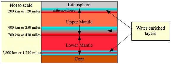
Geochemical experiments show a strong connection between the depths of these discontinuities and transition zones to the expected "phase" transitions or the expected variations in the values of water-saturation concentrations, which should take place under those specific pressure and temperature conditions.
The geochemist Hans Keppler has conducted experiments to determine the water saturation values of the major compounds of the asthenosphere (olivine- 60% and aluminum saturated enstatite- 40%) under the expected pressures and temperatures of the asthenosphere 3. He found that the saturation capacity of this mixture reaches a minimum value exactly within the asthenosphere. In other words, both in the lithosphere above and in the upper mantle's layer beneath, the water saturation concentrations are higher than those of the asthenosphere. Keppler concluded that the asthenosphere is over-saturated, while the immediate layers above it and beneath it are under-saturated. An increased water concentration usually weakens the rocks and decreases its melting temperatures. Keppler explained that in the asthenospheric conditions water-saturation or over-saturation causes a partial melting of the rocks. This partial melting is what enables the asthenosphere to be very elastic in relation to its surrounding layers. Hence the asthenosphere practically produces the lubricant for the drifting of the tectonic plates. Without the asthenospheric lubrication, it is doubtful if the continents (like all the tectonic plates) could have drifted at all.
As strange as this may sound, I claim that Keppler's discovery actually describes a local balance in the water's solubility. Such a balance can actually occur when a saturated or over-saturated layer lies in between two "dry" layers. The "dry" layers are not waterproof. The water is free to diffuse between the layers. The balance is reached merely by the local combination of chemical and physical pressures.
Due to unique chemical and physical pressures at a given depth, a saturated or even over-saturated layer can exist between two "dry" (under-saturated) layers although these layers are not waterproof. It seems that this is the case in the asthenospheric environment.
Geologists agree that the mantle rocks are not static, but in a constant convecting motion. It is assumed to be a very slow motion, which is only a few centimeters (about an inch) per year4. This motion is derived from the heat of the core and the forces that it exerts upon the lithosphere generate the tectonic drift. In addition, the convection generates a vertical cyclic motion of all the material in the mantle and lithosphere, except that of the continental lithosphere (see the following illustration).
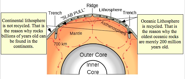
These are the convection currents of the mantle. These currents drive the tectonic plates and generate a vertical cyclic motion of all the material in the mantle and lithosphere, except the continental lithosphere.
(Picture's creator: Surachit5)
Let us imagine a water saturated rock that slowly ascends in the convection currents from the depths of the upper mantle into the asthenosphere. Keppler discovered that in the asthenospheric conditions the saturation concentration of the rocks decreases. But the rock was already saturated prior to its ascension into the asthenosphere. Therefore it becomes over-saturated within the asthenosphere itself. Now the rock must release its excess water to the surrounding environment (see the demonstration in the following illustration).
The water is lighter than the rock and tends to float upwards. Thus, a chemical and physical separation between the rock and the water (or water-enriched magma) takes place. Later on, when the convection currents pull the rock back down beneath the asthenosphere, its excess water remains behind. In principle, I claim that in this manner a great portion of the mantle's rocks dehydrate and become under-saturated. The asthenosphere simply squeezes the water out of the rocks that pass through it. As long as the rock does not accumulate new water in some other layer, it will eventually return to the asthenosphere as a "dry" rock because its water concentration now equals its exact asthenospheric saturation concentration.
The asthenospheric water trap:
-
A saturated rock slowly ascends with the convection currents and enters the asthenosphere.
-
In the asthenosphere the rock's saturation concentration decreases. In addition a partial melt begins.
-
Water and water-enriched magma is released from the rock.
-
The rock descends back beneath the asthenosphere with the convection currents. In the deeper layer its saturation concentration increases, but it contains less water, since it has released its water in the asthenosphere. Hence, it becomes "dry" or under-saturated.
Above the asthenosphere, within the lithosphere, the rocks remain solid. But in some cases water saturated magma, which is formed within the asthenosphere, does ascend into the lithosphere itself. Such movements generate the well known volcanic activity and also a range of intermediate states in which magma partially intrudes into cracks and fractures within the lithosphere. Water saturated magma tends to be lighter than its surrounding environment and therefore it floats upwards as far as it possibly can. When the magma approaches the surface and the ambient pressure descends beneath the water's critical pressure, the water vaporizes and departs from the magma as steam. This phenomena makes it difficult to properly estimate the original water concentrations within the magma. Fortunately, in volcanic eruptions we also find stones, which solidified at early stages of the magma's ascension prior to the release of the water. These stones are called "Melt Inclusions". They typically contain very high water concentrations (3-7%) 6. Melt inclusions from Hawaii imply that a partial melting of the rocks began far deep in the asthenosphere at a depth of 250 kilometers (155 miles)7. These findings strengthen the claims that the asthenosphere is indeed saturated or over-saturated with water. Furthermore, they strengthen the claims that water enriched magma does leak upwards from the asthenosphere into the lithosphere and form the mechanism through which water is recycled back into the hydrosphere.
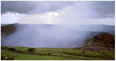
The Masaya Volcano in Nicaragua constantly releases gas, mainly steam, without releasing magma. These gases are volcanic gases, which originate from deeper magma. The Canadian geologists John Stix published on 2007 an article that explains the mechanics of this phenomena 8. The phenomena demonstrates a "passive eruption". A non-violent eruption of magmatic gas, in which the magma itself does not reach the surface.
(Source of the picture: Wikipedia-anonymous source9)
As we descend deeper into the mantle we find the beginning of the "transition zone" at a depth of around 410 kilometers (255 miles). This zone defines the transition from the upper mantle to the lower mantle. It is a relatively thick layer, which continues until a depth of 700 kilometers (435 miles). Like in the case of the asthenosphere, it seems that this layer is also water enriched, maybe even over-saturated. During the previous decade a group of geologists from Yale University has conducted an extensive research on this layer. They tried to understand why so much water seems to be locked within this layer, while the layers above it and beneath it seem to be under-saturated. They presumed that the transition zone acts as a filter both for water and for other elements of the mantle10.
At a depth of 410 kilometers (255 miles), where the transition zone begins, the unique pressure and temperature conditions cause a phase transition in the rock's crystal structure (Olivine to Wadsleyite). It is important to understand that a "phase" transition is not necessarily a transition from solid to liquid or from liquid to gas. In this case, the phase transition is merely a transition in the internal arrangement of the atoms within the crystal. The same mixture of minerals reshapes its crystal structure in correlation with pressure variations. However, this phase transition has a major effect on the rock's water saturation concentration. It sharply decreases when the rock crosses the transition zone. The geologists calculated that the saturation concentration at a depth of 410 kilometers is merely 0.05%. They estimated that ascending rocks from the lower mantle contain around 0.1% water. This means that the rocks of the lower mantle must release half of their water content as they ascend with the convection currents into the transition zone .
The release of the water also generates a partial melt (only 10%) of the rocks in the transition zone. The water enriched magma that is formed by this partial melting is lighter than its initial environment and therefore tends to float upwards to the most upper portion of the transition zone. But it also contains several heavier elements, which have ascended from the lower mantle and are "incompatible" with the upper mantle. Thus, the magma of the transition zone does not continue its ascension into the higher layers of the upper mantle. Its buoyancy has an intermediate value. Eventually, when it cools down, it becomes denser and heavier and sinks back into the lower mantle (see the following illustration).
In this process, the partial melting of the original rocks practically filters the mixture. The heavy and "incompatible" elements sink back with the magma while the lighter and "refined" rocks continue upwards into the upper mantle. This is the reason why the researchers named their model: " the transition zone water filter model".
Since most of the water that the rock initially contained is extracted from the solid rock into the melt and the melt does not continue to ascend, the upper mantle above the transition zone is practically "dehydrated". Once again, we receive a picture similar to that of the asthenosphere. The balance is achieved when the over-saturated layer is locked in between two under-saturated layers.
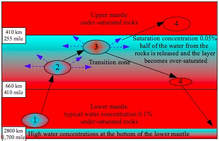
The transition zone water filter
-
The water concentration in the lower mantle's rocks is estimated as 0.1% and it is commonly claimed that they are under-saturated. The rock in this example slowly ascends with the convection currents.
-
In the transition zone the saturation concentration decreases below the water's actual concentration and the rock begins to partially melt. Excess water is released.
-
At a depth of 410 kilometers (255 miles) the saturation concentration decreases to a minimum value of 0.05%. Thus, half of the rock's original water must be released up to this point. In addition, the rock completes a partial melt of 10%.
-
The melted part of the rock contains heavy elements and hence cannot continue to ascend. It cools down, sinks back to the lower mantle and solidifies under the increasing ambient pressure. The rest of the rock is lighter and therefore continues with the convection currents into the upper mantle. Both rocks leave the transition zone in an under-saturated state, but the rocks that ascend to the upper mantle are practically dehydrated.
A short while before the publication of this book (in 2012), a group of geologists from a variety of Japanese Universities published surprising estimations for the water concentrations in the core-mantle boundary and also for the core itself 11. They estimated water concentrations within the range of 1-2%, which is 10-20 times higher than the estimated concentration for the lower mantle. They claimed that the core-mantle boundary absorbs the remains of the descending oceanic lithosphere and finally melts it together with all its remaining water (see the following illustration). The light silicate oceanic crust cannot descend further down into the heavy iron-nickel core and its remains float upon it. But its water, or the elements of its water (hydrogen and oxygen) are free to diffuse between the melted layers. The Japanese geologists claimed that the water diffuses into the core itself. They found that the water concentrations, which they received in their laboratory experiments, can explain a well known offset in the core's density.
What prevents the water in the core-mantle boundary from ascending into the lower mantle and saturating its rocks? I have not yet found research that answers this question and I would be glad to receive new information on this issue. As I mentioned in the beginning of this chapter, the actual saturation concentrations of the mantle rocks in general may be lower than what is estimated today. The rocks of the lower mantle may in fact be saturated already. On the other hand, the core-mantle boundary, like the asthenosphere and the transition zone, may have its own complex filtering mechanism. A mechanism that acts to lock the water within the layer and dehydrate those rocks, which ascend in the convecting currents.
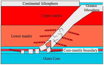
The oceanic lithosphere gradually melts and decomposes as it descends into the lower mantle. The red arrows represent its melting into the mantle. Its remains float upon the outer core in the core-mantle boundary and they all eventually melt there. All the water, that was absorbed by the oceanic lithosphere and that survived its descent through the mantle, is released into the core-mantle boundary and may even diffuse into the core itself.
We have seen so far that there are at least 3 saturated or over-saturated layers within the mantle. Most recent findings reveal the existence of additional, but thinner, over-saturated layers. I did not discuss these findings, but in principle their existence should probably be attributed to similar water filtering mechanisms. We have understood how these layers act within the context of the convecting currents to absorb the waters of the rocks that pass through them. It can now be understood how vast areas of the mantle may become apparently dehydrated, even if the whole mantle is in fact saturated. Taking into account these dehydration mechanisms, the mantle may have a complex mosaic of under-saturated, over-saturated and saturated layers in the local scale and still be saturated in the wider scope.
Parallel to the water absorption in the transition and discontinuity layers there are two major vertical water transportation mechanisms in the mantle:
The first water transportation mechanism is the oceanic lithosphere, which supplies the entire depth of the mantle with additional water all throughout its descent. The further it descends and heats up, its saturation concentration decreases and more water is released. Most of the water is released already when it passes through the asthenosphere and maybe even prior to that. The remaining water is gradually released throughout its entire descent. Eventually, all the remaining water is extracted from the lithosphere at the core-mantle boundary. This is the factor, which transports the water downwards. The water, which is transported by this factor is mainly oceanic water that was absorbed by the oceanic lithosphere.
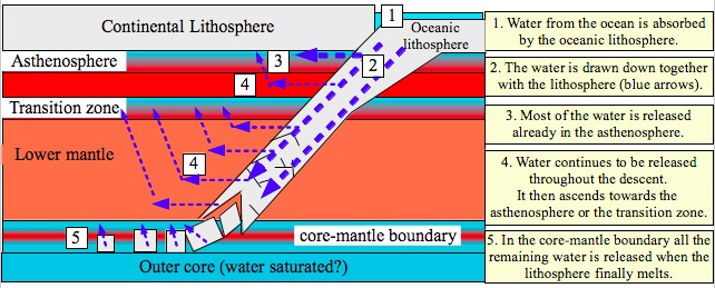
The second water transportation factor is located in the ascending convecting currents. Earth's internal heat originates mostly from its core. At the core-mantle boundary the heat generates uplifting currents of magma and rock. These currents slowly ascend to the surface and eventually create the oceanic volcanic ridges, as well as new rifts (like the Great Rift Valley) and "hot spots" (like the Hawaiian Islands). The forces, which are derived from these currents generate tectonic drifting. The existence of these currents has been proven in many seismic tomographies.
In the tomographies, the ascending currents are recognized as vertical plumes with lower densities. The lower densities are usually related to the higher temperature of the material within these plumes. But is it possible that these ascending currents, which cut through all of the mantle's depth also produce a vertical path for water transportation? Is water transported between the mantle's layers and eventually also into the lithosphere and hydrosphere through these plumes? It is known that the presence of water in rocks and magma decreases the material's density. Is it possible that at least some of the density's reduction is due to an increased water concentration instead of heat? To my best knowledge these questions cannot yet be answered. I presume that the answers are "yes".
To summarize, now that we have collected some basic and essential data, we may build a general model for the planetary water cycle, which is demonstrated in the following illustration:
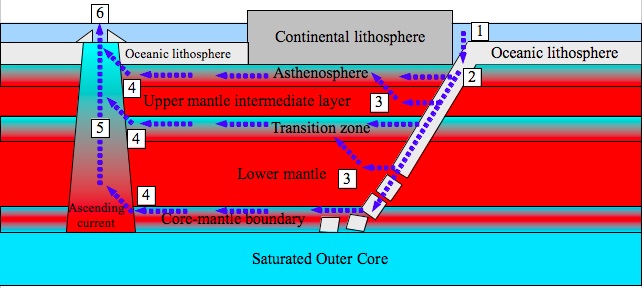
The Planetary Water Cycle:
1) Ocean water is absorbed by the oceanic lithosphere. 2) The water is transported together with the descending lithosphere into the depth of the mantle. When the temperature rises the saturation concentration of the water in the lithosphere decreases and water must be released. Most of the water is already released in the asthenosphere. 3) The lithosphere continues to release the remaining water throughout its descent. The water may diffuse or be transported upwards into the asthenosphere or into the transition zone. In the core-mantle boundary all the remaining water is released when the lithosphere is finally melted. 4) The excess water is pushed by chemical-diffusive pressure along the different transition and discontinuity zones until it reaches the ascending convection currents. 5) The water is transported upwards by the ascending convecting current and maybe also by diffusion. 6) The water is released back into the oceans (and the entire hydrosphere) through the oceanic volcanic ridges and the "hot spots".
In this chapter I have presented a planetary water cycle model, which is presumed to work "as a routine" at a very slow rate. The waters of Earth are (allegedly) in balance according to the proposed planetary cycle. The energy, which produces this cyclic movement and its balance, is supplied by Earth's greatest nuclear power station: the constant and stable radioactive decay of elements in its core. If we add to this system a substantial external energy source (for example, extreme tidal forces), then the planetary water cycle will quickly lose its balance. In the following chapter we will try to understand how this scenario could have triggered the release of the waters of the great deep.
2 Shun-ichiro Karato, David Bercovici, Garrett Leahy, Guillaume Richard and Zhicheng Jing.Yale University, Department of Geology and Geophysics, New Haven. The Transition-Zone Water Filter Model for Global Material Circulation: Where Do We Stand? http://earth.geology.yale.edu/~dberco/papers/2006/WaterFilter-AGU-Monograph2006.pdf
3 Ms. Sofia Valleley. Keeping the Earth's plates oiled. 1. June 2007. European Science Foundation. http://www.esf.org/research-areas/life-earth-and-environmental-sciences/news/ext-news-singleview/article/keeping-the-earths-plates-oiled-296.html
4 Whole mantle convection
6 Dissolved Volatile Concentrations in Melt Inclusions . Yellowstone Volcano Observatory. Volcano Hazards Program. USGS. http://volcanoes.usgs.gov/observatories/yvo/jlowenstern/meltinclusions/volatiles.php
7 Wallace, P. J. (1998),Water and partial melting in mantle plumes: Inferences from the dissolved H2O concentrations of Hawaiian basaltic magmas,Geophys. Res. Lett., 25(19), 3639-3642, doi:10.1029/98GL02805. http://www.agu.org/pubs/crossref/1998/98GL02805.shtml
8 John Stix (2007), Stability and instability of quiescently active volcanoes: The case of Masaya, Nicaragua, The Geological Society of America. http://geology.gsapubs.org/content/35/6/535.abstract
10 Shun-ichiro Karato, David Bercovici, Garrett Leahy, Guillaume Richard and Zhicheng Jing.Yale University, Department of Geology and Geophysics, New Haven. The Transition-Zone Water Filter Model for Global Material Circulation: Where Do We Stand? http://earth.geology.yale.edu/~dberco/papers/2006/WaterFilter-AGU-Monograph2006.pdf
11 Terasaki,Hidenori; Ohtani,Eiji; Sakai,Takeshi; Kamada,Seiji; Asanuma,Hidetoshi; Shibazaki,Yuki; Hirao,Naohisa; Sata,Nagayoshi; Ohishi,Yasuo; Sakamaki,Tatsuya; Suzuki,Akio; Funakoshi,Ken-ichi; Stability of Fe-Ni hydride after the reaction between Fe-Ni alloy and hydrous phase (δ-AlOOH) up to 1.2 Mbar: Possibility of H contribution to the core density deficit , Physics of the Earth and Planetary Interiors, Volume 194, p. 18-24. (PEPI Homepage), 03/2012, http://adsabs.harvard.edu/abs/2012PEPI..194...18T
10. The water release
In chapter 6, I mentioned the exceptional tidal forces upon Jupiter's moon Io. As recalled, the earth of Io routinely rises 100 meters (330 feet) at high tide. Most people are unaware that Earth's ground also rises routinely at high tides. However, our earth tides are measured by no more than a few centimeters (around an inch)1, since Earth is subjected to much weaker tidal forces. But if a great mass passes close enough to us, we may also find ourselves in Io's condition. In fact our condition may be even worse, since Earth seems to contain much more water than Io does. Let us investigate further what goes on in Io and try to infer what might happen to Earth in a similar scenario.
Generally, when a physical force acts upon some given body, that force is actually passing energy to the body. The tidal forces are in fact expressions of gravitational energy that is received by the given planet or moon, which they act upon. Routinely, the ocean tides express gravitational energy, which Earth receives from the Moon and Sun. The tides upon Io express gravitational energy, which Io receives from Jupiter and its moons Europa and Ganymede. Through tides, gravitational energy is transformed into "kinetic energy"; i.e. energy that is related to motion. In Greek, "kinein" means "to move".
When the average motions of all the molecules within a given body are in the same direction, then the entire body moves in that direction. However, if the average motion of all the molecules counterbalances each other then the kinetic energy of the body becomes heat. Apparently, the temperature of a body is a direct expression of the kinetic energy of its molecules (see the following illustrations). The energy, which is received through the tidal forces, is initially expressed by tides, but it eventually transforms into heat.
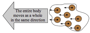
When all the molecules have an average motion in the same direction, then the entire body moves as a whole in that direction.
When the molecules move in different directions, causing their average motion to counterbalance each other, then the body as a whole does not move at all. In this state the motion of the molecules is in fact expressed as heat. If the molecules have low average velocities, then the body has a low temperature (as in the left illustration). If the molecules have a high average velocity, then the body has a high temperature (as in the right illustration). The lengths of the arrows in the illustrations note the velocities of every corresponding molecule.
In Io the tidal heating is so intense, that it melts vast areas within its mantle2. The heat generates internal magmatic currents and intense volcanic activity. That is why Io is full of volcanoes and contains mountains higher than the Everest 3. In Earth, the internal heating is mainly related to the constant radioactive decay of heavy elements in its core. But in Io it is estimated that the tidal heating is 200 times greater than its internal radioactive heating.
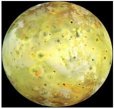
A picture of Io. The face of Io is scared from volcanic activity.
(Source of picture: NASA4)
In the previous chapters I have mentioned that Earth's core and mantle seem to contain great quantities of water. This water isn't free, but is dissolved within the rocks and magma.
How would an internal heating of Earth affect the water, which is dissolved within it?
The geochemists are trying to find the answer to this question through laboratory experiments. They use mineral compositions, which simulate, to the best of their knowledge, the compositions of the minerals in the core, mantle or crust. They saturate the minerals with water and subject them to intense pressures, while heating them up to temperatures of hundreds or thousands of degrees (Celsius or Fahrenheit). They estimate that these conditions resemble the conditions in different layers of Earth's interior. This type of research demands a continuous data collection from numerous experiments, since there is a huge span of possible pressures and temperatures throughout Earth's interior.
In addition, the same mineral mixture may undergo substantial phase transitions in correlation with pressure and temperature variations. The water saturation concentration of the mineral mixtures depends on all the factors: composition, pressure, temperature and phase. As if to complicate this issue even more, it has been discovered that small variations in the mixture's composition, for example very small variations in the concentration of iron, may dramatically change the features of the whole mixture. One of the major problems is that our knowledge of the mantle's and core's composition still lacks a necessary final refinement. However, due to the work of many geochemists, it is possible to estimate the saturation concentration of a given layer within Earth's interior. Many experiments show that within the pressure and temperature span, which is typical to the upper mantle, heating tends to decrease the saturation concentration of the mixtures. The excess water tends to separate from the mixture and ascend 5.
In general, the mantle's rocks tend to release water when they are heated, but if they are heated until they melt, then they will release much greater quantities. The melted rocks form "magma". In an over-saturated magma, the water that was previously chemically bound to the minerals of the solid rock, is now free to "nucleate".
We all see an example for nucleation every time that we open a soda. The formation of the bubbles in the soda expresses the nucleation of dissolved carbon dioxide within the soda solution, which suddenly becomes over-saturated. This carbon dioxide- water solution becomes over-saturated because the opening of the bottle or can immediately decreases its pressure. This act is called "decompression" and it causes an immediate decrease in the saturation concentration of the solution. The nucleation tends to occur around "nucleation seeds". The excess carbon dioxide molecules in the over-saturated soda are repelled from the water molecules and they attach to any other substance that does not repel them. Any "impurity" within the soda will do. Bubbles will form around any piece of dust, any mineral, on the sides of the glass and even around your finger (see the following picture).
In the over-saturated magma, water nucleates around different impurities within the mixture and forms bubbles similar to those of the soda's carbon dioxide. But in this case, due to the intense pressure, the bubbles are composed from a supercritical fluid instead of a gas. Once the first bubbles have formed, they begin to unite with each other and generate greater and greater volumes of free water, which can float upwards. But even if the magmatic water does not nucleate, it is still relatively free to diffuse from areas with high water concentration to areas with low water concentration.
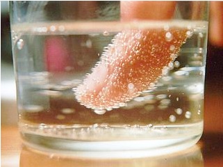
This is an example of nucleation. Carbon dioxide nucleated around a finger in the given soda. This soda is in fact a carbon dioxide over-saturated solution. The water molecules repel the excess carbon dioxide molecules. In response, the carbon dioxide will attract to any alternative substance and nucleate around it. Similarly, water in an over-saturated magma nucleates around different "impurities" within the magma and creates "bubbles" of supercritical fluid. The water bubbles float upwards similarly to the carbon dioxide bubbles in the soda.
(Source of the picture: Arie Melamed-Katz6)
Phase transitions in the mantle's rocks may also cause a sharp variation in the saturation concentration. For example, consider the solubility of salt in sea water. It hardly varies between the water's freezing temperature and boiling temperature, but the moment that the seawater begins to freeze and becomes sea ice a chemical separation between the salt and the water occurs. The salinity of the sea ice decreases to a third of the seawater's salinity.This sharp decrease occurs within a minor temperature difference of several degrees 7. The solubility of salt in seawater sharply decreases in this liquid to solid phase transition. Similarly, the solubility of water in the mantle's rocks is also very sensitive to phase transitions.
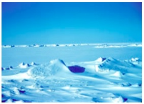
A picture of sea ice.
(Source of the picture: NOAA8)
The water, or the water-enriched magma, can ascend until it is stopped by a solid waterproof layer. There it will accumulate. If it has the possibility of breaking its way further up it will do so. Waterproof layers will exist in areas that were less heated or in areas that remained solid, despite their heating, due to their special chemical composition and their environmental conditions.
In Io we see that the moon's crust remains cold and solid and its lithosphere continues some 50 kilometers (30 miles) down, despite the fact that the extreme tidal forces melt its mantle rocks9. How is this possible? Shouldn't Io's crust also melt?
Eventually most of the energy is transformed into heat where friction is formed between the layers. Consider the brakes in your car. When your car drives at a speed of 100 kilometers per hour (62 miles per hour) and then you suddenly push on its brakes, its kinetic energy is transformed into heat. But the brakes themselves absorb most of the heat. Within the car we don't feel that it heated up. The excess heat is rapidly radiated from the brakes to the surrounding air and we may continue to drive safely. Similarly, in Io there is a layer, which absorbs the transformation of the energy from kinetic energy to heat. This layer is expressed as a magmatic ocean, 50 kilometers (30 miles) beneath the surface.
Which layers within Earth may absorb the gravitational energy? Think about a tower of blocks. Imagine that you shake and vibrate the tower. How would the motion that you are passing to the tower be transformed into friction and heat within the tower itself?
If we shake a tower of blocks, which layers will eventually absorb the kinetic energy, turn it into friction and heat up?
On the right side we can see a stable tower. In the middle we can see a tower that is shaken. Its blocks are rubbing against each other. It is evident that most of the friction is in between the blocks and not within the blocks themselves. On the left side we can see an irrational scenario, in which the kinetic energy causes the blocks to break instead of rubbing them against each other.
The tower example comes to show us that solid bodies move as single blocks. The friction, which originates from motion in opposite directions, is formed between one solid body to another and not within the solid bodies. Due to the friction, the motion of the bodies quickly stops when the external force ceases. In Earth, like in the tower, the lithosphere is the most upper solid "block". The second "block" is an intermediate layer within the upper mantle. The lower mantle is the third block and the inner core is the forth block. In between these solid "blocks" lie the melted (or partially melted) layers: the asthenosphere, the transition zone and the core-mantle boundary together with the liquid outer core. The melted layers are weaker and hence act like the spaces between the tower's blocks. The friction will mainly occur in these melted layers. Therefore, most of the tidal heating will eventually take place in these layers.
Earth's solid layers are an analogue of the blocks in a tower (see previous illustration). The melted or partially melted layers are an analogue of the spaces between the tower's blocks. Hence, if we keep the metaphor of the shaking tower in our minds, it follows that the kinetic energy of the tides will eventually transform into friction and heat within the asthenosphere, the transition zone, the core-mantle boundary and the outer core.
It follows that an additional melting will occur in those layers which are already partially melted. An additional melting can be expressed as a melting of higher percents within the layers themselves, for example 20% instead of 10% in the transition zone and also as an expansion of the melted layers into their surrounding layers. In addition, a high tide causes a temporary decompression. Melting is easier at lower pressures, thus the decompression which is associated with the high tides may also contribute to increase the melting.
As recalled, the melting of the mantle's rocks can cause it to release its dissolved water. Since we are speaking about a transitional phase, the variations in the saturation concentrations may be extreme. Under these conditions, the transition and discontinuity zones, which are already saturated or over-saturated, will collect too much excess water. The extreme over-saturation of these layers will enhance the formation of water "bubbles" within the magma. In addition, the "squeezing" action of the tides resembles the shaking of a coca-cola bottle. It is well-known that when you shake a coca cola bottle you generate many more bubbles. Then, if you open the bottle you may enjoy a small fountain. Similarly, the repeating tidal squeeze of Earth's internal layers should enhance the creation of water bubbles.
The water supercritical fluid bubbles will "try" to ascend due to their buoyancy. They are expected to drag diluted magma together with them as they ascend. The most natural path for the release of the water is through the mantle plumes, where the ascending convecting currents pass. I do not mean that the rocks and magma within these plumes will ascend. What I mean is that the water will find the best conditions to seep or diffuse upwards through the rocks and magma of the plumes.
The mantle plumes lead upwards to the "rifts"; i.e. to the areas, in which the Earth's lithosphere is being pulled apart. The ascending water will quickly reach the rifts. Most of all, these rifts form the oceanic ridges. Since the water concentration within the magma will be extremely high, the magma itself will be extremely diluted. This characteristic of the magma will enable an easy and rapid release of water as well as other volatiles through the volcanoes and through cracks in the lithosphere.
Under such conditions the water release does not have to be accompanied by violent volcanic eruptions. The water will be released as steam in areas where the ambient pressure is lower than the water's critical pressure, for example in land volcanoes. And it will be released as liquid water in areas where the ambient pressure is greater than the water's critical pressure, for example along the oceanic ridges at depths beyond 2,180 meters (7,150 feet). Most of the water will be released at a liquid phase into the depths of the oceans, through the oceanic ridges, which have a cumulative length of dozens of thousands of kilometers (or miles).
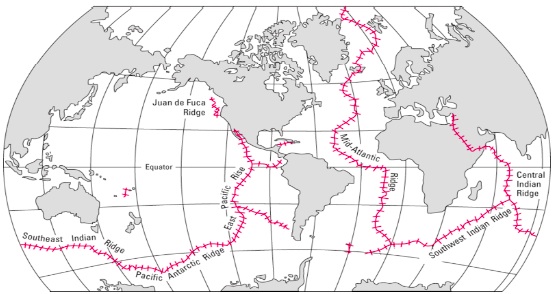
A global map of the oceanic ridges (marked in red). These ridges are the end products of the ascending convecting currents, which rise from the core-mantle boundary through the mantle plumes all the way up to the bottom of the ocean and in some cases even to the surface of the land. Along these ridges there are dozens of thousands of kilometers (or miles) of volcanoes (mainly submerged), gas vents and hot springs. I claim that the release of the water in the Biblical flood took place mostly through these ridges.
(Source of the picture: USGS10)
The water that is released from the great deep will of course be very hot. The "Talmud" is a central rabbinic text, considered second to the Hebrew Bible, which was written throughout the last centuries BCE and the first centuries CE. Tractate Sanhedrin, a section of the Talmud, mentions (on sheet 108, page 2) that the waters of the flood were "thick as semen" and were boiling until the 150th day of the flood. I thank Uriel Farjon for this information.
Dr. Hadassah Melamed has published an interesting flood theory of her own in her book " The Secret of the flood, the Bermuda Triangle and the Migration of Continents" (originally written in Hebrew in the year 2000, but she is working now on an English and Russian translation. A summary in English can be found at this link 11). We have been discussing our theories throughout the last year (2012). We are in dispute on several major issues, but I must mention that she has interesting ideas and that she has gathered a huge amount of rabbinical information regarding the Biblical flood. This information repeatedly strengthens the claims that the waters of the flood were hot and that the flood was accompanied by massive volcanic eruptions, earthquakes and tectonic movements.
Dr. Immanuel Velikovsky, who was one of the greatest researchers that tried to scientifically explain many issues of the Torah, conducted an extensive worldwide comparative research on the tales and ancient scriptures of the different nations. It is well known that he found that the description of the Biblical flood is repeated in nearly every culture of the world. But he also found that many described the same side effects: massive and extensive volcanic eruptions. The waters that flooded the world are often described as hot. His manuscripts on the issue of the flood were never published as a book, but his daughter Shulamit Velikovsky Kogan has made them available on her web site ( http://www.agesinchaos.org.il ).
The research of Dr. Immanuel Velikovsky triggered numerous academic disputes throughout the years 1950-1980. I think that his work has not yet been sufficiently appreciated. They have drawn a lot of criticism. These issues can be discussed at length. However, even his critics cannot disregard the fact that Velikovsky collected and compared a massive and probably unprecedented amount of raw material. The raw material still exists and it is very clearly described.
A full and detailed discussion on the the flood related research of Dr. Immanuel Velikovsky and Dr. Hadassah Melamed demands a separate book. Its composition is one of my future projects.
The water of the flood was not released uniformly from all the melted layers. I assume that it was more difficult for water from deeper layers to break its way through the mantle up to the surface. An important question that must be answered is whether or not it is possible that water will seep or diffuse upwards from depths of hundreds or even thousands of kilometers (or miles) within a time span of several months.
The best and most logical candidate for the water release is the asthenosphere. It is the closest to the surface. This layer is positioned straight beneath the lithosphere "only" 100-200 kilometers (60-120 miles) beneath the surface. In addition, the asthenosphere is expected to heat up more than the deeper layers. Why? I will use the following illustration to demonstrate the answer:
The tidal forces (blue arrows) are weaker as we go deeper. This is represented by the shorter lengths of the arrows. The reason for this phenomena is that the tidal forces express the difference between the intensity of the gravitational force that the cosmic cloud (in this case) applies upon a given mass unit in Earth and the gravitational force that the cosmic cloud applies upon a mass unit in the center of Earth (see detailed explanations in chapter 5). Correspondingly, the intensity of the tides in the different layers depends on their depths. The strongest tidal forces act upon the lithosphere and the intermediate mantle layer. Therefore, amongst the melted layers, I assume that the asthenosphere, which separates between the lithosphere and the intermediate mantle, will absorb most of the friction and heat.
In the evaluation of the speed of the water release, we must take into account not only the depth of each melted layer, but also the direct effect of the tidal forces on the solid layers. Most of the tidal energy will indeed be transformed through friction into heat within the melted layers, but it will also necessarily generate cracks and fractions in the solid layers. The analogy of the solid layers to the blocks of a tower is not really accurate, since Earth's layers are spherical and not shaped as cubes. The tidal waves practically squeeze the layers and release them over and over again. Over-saturated magma and even free water will easily break its way up through fresh cracks and fractions. This scenario enables a rapid transportation of water from one layer to another as well as to the surface itself, even in areas which are far away from the rifts. The same conditions may even cause "regular" aquifers to break and burst upwards.
The tidal waves within the lithosphere will necessarily generate cracks and fractions. Through these cracks and fractions, over-saturated magma and even free water will break its way up. The closer the magma approaches to the surface and the ambient pressure decreases, the easier it becomes for the water to separate from the magma and burst upwards as free water. In addition, the cracking of the lithosphere also enables the breaking of "regular" aquifers within it.
Any high tide is also accompanied by a low tide. While half of the planet is experiencing a high tide, the other half is experiencing a low tide. In areas that experience a high tide it will be easier for the water to be released, since the temporary decompression, which originates from the high tide, eases the formation of the water bubbles and their ascent. On the other hand, in the areas that experience a low tide the water's ascent will be delayed, since the layer will be temporarily compressed. But what is more important and effective is that the compression of the lithosphere during low tides will also temporarily close the cracks and fractions and prevent the released water from returning to the depths. I claim that in this manner the lithosphere itself will act like a one-way valve. Water will easily ascend to the surface during high tides, but its way back down will be blocked. See the demonstration in the following illustration.
Under extreme tidal forces (blue arrows) the lithosphere acts like a one-way valve. The high tides widen cracks and enable magma and free water to break its way out to the surface (blue lines). The low tides compress the lithosphere and close back the cracks (black lines), so the water that is pumped to the surface during high tides cannot return to the depths of the Earth during low tides.
As recalled, I claim that the water was released at high temperatures as steam or supercritical fluid. However, the water that was released deep in the sea as supercritical fluid must have also ascended to the surface of the sea and vaporized in the lower ambient pressure. The atmosphere quickly filled up with water vapor in quantities that far exceeded its saturation concentration. Hence, the water had to pour back down upon the earth as intensive rain. These were the famous rains of the flood. Water that burst out from the great deep, vaporized into the atmosphere and poured back down as intensive rain.
The water release played an important role as it also released the excess tidal energy back into Space. The water that rose to the surface in fact transported, in the form of heat, the original gravitational energy, which earth absorbed from the cosmic cloud. When the water vaporized, that same energy was radiated from the water back into Space. In atmospheric ambient pressure, rain cannot pour down if the temperature is higher than 100 degrees Celsius (212 degrees Fahrenheit). Only water vapor, which radiated enough energy back into Space, could cool down and condense into rain. The cooled water that returned later on to Earth's interior only helped our planet to thermally rebalance. The whole process is demonstrated in the following illustrations.
Actually, the model that I am proposing forms a simple control mechanism for Earth's interior temperature. Due to its water, Earth cannot accumulate external energy for long. It must radiate the energy back into Space. This is how our planet can quickly recover from cosmic shocks. I call this model "The Planetary Radiator", since its principle mechanism resembles the mechanism of the water-radiators in the engines of our cars. The only difference is that the planetary radiator cools down an entire planet.
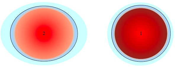
The Planetary Radiator
1) Routinely, there is a thermal balance in Earth that is based upon its constant radioactive radiation, which heats its core.
2) The irregular and extreme tidal forces, which acted upon earth, mainly heated its mantle. This heating is presented in the illustration by the changing of the mantle's color into bright orange.
3) Due to its heating, the mantle began to release hot water (red arrows) into the hydrosphere (blue layer) and into the atmosphere. The water release enabled the mantle to release its excess heat. The atmosphere absorbed the water and also heated up (this is presented by its color changing from pale green to pale orange).
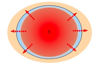
4) The excess heat was rapidly radiated from the atmosphere and hydrosphere into Space (red arrows).
5) The cooled water eventually returned to the mantle (blue arrows) and cooled it back to its regular temperature (this is presented by the changing of the colors back to the original dark colors).
As long as Earth was still within the cosmic cloud, it experienced irregular tidal forces over and over again. Its interior continued to heat up and water continued to be released to the surface, although not necessarily at a uniform rate. But immediately when the cosmic cloud released its hold, the whole system strived to rebalance. How did the water seep back into the depths of Earth? At which rate did it do so? That is the subject of the next chapter.
1 John Wahr, Earth Tides, Global Earth Physics, A Handbook of Physical Constants, AGU Reference Shelf, 1, pp. 40-46, 1995.
2 Rosaly MC Lopes (2006). Io: The Volcanic Moon. In Lucy-Ann McFadden, Paul R. Weissman, Torrence V. Johnson.Encyclopedia of the Solar System. Academic Press. pp. 419-431.ISBN 978-0-12-088589-3.
3 Schenk, P.; et al. (2001). The Mountains of Io: Global and Geological Perspectives from Voyager and Galileo. Journal of Geophysical Research 106 (E12): 33201-33222.Bibcode 2001JGR...10633201S. doi:10.1029/2000JE001408.
5 N. Bolfan-Casanova, Water in the Earth's mantle, doi: 10.1180/ 0026461056930248; Mineralogical Magazine June 2005 v. 69 no. 3 p. 229-257, http://minmag.geoscienceworld.org/content/69/3/229.abstract
7 ESR (Earth and Space Research, A non-profit research institute). http://www.esr.org/outreach/glossary/sea_ice.html
9 Kerr, R. A. (2010). Magnetics Point to Magma 'Ocean' at Io. Science 327 (5964): 408-409.doi:10.1126/science.327.5964.408-b. PMID 20093451.
11 A summary in English can be found in the following link: http://sfile.f-static.com/image/users/59888/ftp/my_files/Summary-Hadassah%20Melamed.pdf?id=11515591
11. The water absorption
On the 150th day of the flood the cosmic cloud departed from Earth. Within a day and night the distance between the cosmic cloud and Earth grew enough to decrease its tidal effect on Earth to negligible levels. The factor that squeezed and heated Earth up throughout the first 5 months of the flood, suddenly lost its effect. Earth was now free to rebalance and its water played a central role.
How fast was the water absorbed?
In chapter 7, I concluded that the real flood level should have had some value within the altitude range of 3,000-5,137 meters (9,842-16,854 feet). According to Ramban, the mountain tops in the region of Mount Ararat were seen 73 days later. From the topographic data I concluded that the flood level, on the day when the mountain tops were seen, should have had some value within the altitude range of 3,000-4,000 meters (9,842-13,124 feet). This data enables us to determine that the flood level did not decrease by more than 2,137 meters (7,011 feet) within 73 days. This is the upper boundary for the rate in which the water was absorbed. But we still don't have enough data to determine the lower boundary. We may find some clues for the lower boundary if we reexamine the story of the raven, the dove and the famous olive leaf.
"And it came to pass at the end of forty days," (after the mountain tops were seen) "that Noah opened the window of the ark which he had made: And he sent forth a raven, which went forth to and fro, until the waters were dried up from off the earth."
(Genesis 8: 6-7, King James' translation)
From these verses it is evident that most of the land was still flooded 40 days after the mountain tops were seen. That is why the raven "went forth to and fro". The mountain tops were indeed seen, but it is well known that food and vegetation can hardly be found at high altitudes. This situation also continued when Noah sent the dove:
"Also he sent forth a dove from him, to see if the waters were abated from off the face of the ground;"
(Genesis 8: 8, King James' translation)
On its first time "the dove found no rest for the sole of her foot" (verse 9) and returned to the ark. Rashi explained that the dove was sent 7 days after the raven. Ibn Ezra and Ramban strengthen this determination. The origin of this determination is implied by verse 10 (when the dove was sent for the second time):
"And he stayed yet other seven days; and again he sent forth the dove out of the ark;"
-
In the original Hebrew text this point is even clearer.
Only then, 61 days (40 + 7 + 7 + 7) after the mountain tops were seen, the dove did find rest for the sole of her foot and returned to the ark with "an olive leaf pluckt off" (verse 11). And then, as if to make it totally clear, it is written:
"...so Noah knew that the waters were abated from off the earth."
It is a common mistake to think that all trees quickly die and rot when they are submerged. There are records of trees that have survived the submergence of their entire foliage for more than a month. Furthermore, they had survived during their growing season 1. Their survival capabilities are expected to be even better when they are dormant. Some trees have managed to recover from violent tsunamis, even after their ground was soaked with seawater for months long. Therefore, I assume that the olive leaf, which the dove found, did indeed originate from an olive tree that had survived several months of flooding and was eventually revealed when the water level decreased.
What can we learn from all the data above on the water's level? In order to answer this question we must first inquire as to what altitudes olive trees can be found. Surprisingly, olive trees grow well and are abundant at relatively high altitudes2 , despite the fact that they are usually related to the naturally warm Mediterranean region. Actually the cool environment of the mountains benefits the olive trees. In Spain olive trees are grown today at altitudes of 1,200 meters (3,900 feet). In Morocco they are grown at altitudes of 1,600-1,700 meters (5,250-5,600 feet) and in Argentina at an altitude of 2,000 meters (6,550 feet). Wild species of olive trees are abundant at altitudes of 1,500-2,000 meters (4,900-6,550 feet). I was amazed to find out that due to this quality, there has been an attempt to grow olive trees even in the Nepali Himalayas.
Hence, there is a factual basis to determine that olive trees may be found at altitudes of 2,000 meters (6,550 feet). In chapter 7, I concluded that the mountain tops were seen when the water level was 3,000-4,000 meters (9,842-13,124 feet) above the regular sea level. Now it can be concluded that two months later the water level had decreased to the growth altitude of olive trees, 1,000-2,000 meters (3,300-6,550 feet) above sea level.
Conclusion: In the middle of the 3rd stage of the flood, the water decreased 500-1,500 meters (1,650-4,900 feet) per month.
When did the sea return to its regular level?
"And it came to pass in the six hundredth and first year, in the first month, the first day of the month, the waters were dried up from off the earth: and Noah removed the covering of the ark, and looked, and, behold, the face of the ground was dry. And in the second month, on the seven and twentieth day of the month, was the earth dried."
(Genesis 8: 13-14, King James' translation)
It is written that "the waters were dried up from off the earth" and "the face of the ground was dry", but nearly two more months passed before "the earth dried". Only then could Noah and the inhabitants of the ark finally exit from the ark. What is the meaning of this delay? Why couldn't Noah exit from the ark two months earlier?
In the original Hebrew text the difference is clearer. Two different words are used in these same verses to describe different levels of "dry". The text first uses the verb "har-voo" (חרבו). Rashi and Ibn Ezra helped us to understand the meaning of this ancient verb. According to Rashi and Ibn Ezra it means that the ground was not submerged at that stage, but it was muddy and soft hence it was not practical to exit the ark. It took nearly two months for the ground to dry up to a level that its grains could be separated. As Rashi explains, when the ground is totally dry, you can "scratch" it "properly". Only then could the inhabitants of the ark safely exit the ark.
In contrary to what is commonly thought, this additional data does not supply us with new information about the water's level. It merely supplies us with information regarding the state of the ground around the ark. It can be inferred from this information that the ground dried up very slowly. This may be due to extremely humid air, which could not absorb the water and/or cold temperatures and/or the lack of sufficient sun radiation. The legends state that the radiation of the sun was blocked for an entire year. This information can be found in the works of Dr. Immanuel Velikovsky and Dr. Hadassah Melamed. Anyway, it cannot be inferred from this information that the water level had returned to its regular level.
Conclusion: There is no data regarding the rate, in which the water decreased in the final stage of the flood. It may have taken months and even years for the sea to return to its regular level.
How did the water return to the depths of Earth (to the depth of the lithosphere, mantle and maybe even to the core)?
In order to answer this question we must first consider the critical pressure of the water (as explained in chapter 8). A water column of merely 2,180 meters (7,152 feet) high generates a pressure of around 218 atmospheres, which is the water's critical pressure. Therefore, water cannot boil at any depth greater than 2,180 meters. The water remains liquid (or solid) at any temperature. Under high pressure, water that will contact with hot layers of rock or magma will not boil. If the rock or magma is under-saturated, the water will easily dissolve into it.
The typical depth of the ocean is 4,000-5,000 meters (13,100-16,400 feet). In the oceanic trenches the depth can even reach 11,000 meters (36,000 feet). The ambient pressure in these depths is far beyond the water's critical pressure. The tops of the oceanic volcanoes, within the oceanic rifts, are typically around 3,000 meters (9,800 feet) beneath the sea level. Even at these relatively "shallow" depths the water cannot boil. But all these details relate to our present sea level. The second stage of the Biblical flood ended with a water level around 3,000-5,000 meters (9,800-16,400 feet) higher than our present sea level. Under these conditions, even most of the terrestrial regions were subjected to ambient pressures greater than the water's critical pressure.
In principal, all the layers in the depths of Earth that had released water due to their "squeezing" and heating during the first and second stages of the flood, began to cool down during the third stage of the flood. Therefore, in most cases their saturation concentrations re-increased. This means that they could reabsorb water. Hundreds and maybe even thousands of kilometers (or miles) deep, layers of rock and magma became "thirsty". If the water could have reached them, they would have drunk it immediately. But is this scenario really possible? Can Earth really reabsorb its water at such a rapid rate? As recalled, the water level decreased at a rate of 500-1,500 meters (1,650-4,900 feet) per month throughout the first months of stage 3.
The answer to this question greatly depends on the permeability of the mantle's rocks. Their permeability varies upon a huge range in correlation with different temperatures, pressures, compositions and phases in these layers. To my best knowledge, the permeability values of most of the layers are still unknown (as of 2012). A lot of data has to be collected in order to properly address this issue. However, I assume that the permeability of solid rocks, under such intense pressures, is very low and cannot supply by itself a rapid water absorption. But the absorption rate of a rock layer does not merely depend on its permeability. It also depends on the existence of cracks and fractions within the layer. The solid layers of Earth were probably cracked and fractioned in many places after they were repeatedly squeezed by the massive earth tides. Could these cracks and fractions have survived throughout time under the great pressures of the mantle? And if they could have survived, could the water have penetrated through them at sufficient rates? I haven't yet found information regarding these questions. I would be glad to receive new information.
The solid layers (lithosphere, intermediate mantle and lower mantle) were probably cracked when they were squeezed by the massive tides. Could water have rapidly seeped down through these cracks?
A possibility, which seems very practical is that the water re-dissolved into the magma. Since the magma is in a liquid or semi-liquid phase, it enables the water molecules which are dissolved in it to be more mobile. It is known from experiments that under high pressures water, which contacts magma, can saturate the magma within several days3. In the flood scenario, which is described throughout this book, the magma was over-saturated when it released the water and then remained saturated for a while. But on the third stage of the flood, when the magma began to cool back down, its saturation concentration increased and it became under-saturated. Therefore magma that was in contact with supercritical water began to "drink" the water back. But the magma's thirst was not easily satisfied. It could not easily reach its new saturation concentration. Why? Since oceans of magma lay beneath it and they were thirsty too. The water that was dissolved in the upper layer of the magma just continued to diffuse further down and it did so rapidly. The magma-water contact line acted like a bottleneck for the deeper layers. The "bottle" did not fill up until all the magma beneath its "neck" was saturated.
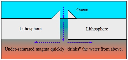
When the magma began to cool down, supercritical water dissolved into it (for example, through submerged volcanoes). The upper magma layer could not reach saturation as long as "oceans" of magma beneath it didn't also reach saturation. This is because any increase in the water concentration generated a diffusive pressure that pushed the water further down.
-
So far experiments have demonstrated how long it takes to bring a sample of magma to saturation of water. But in order to validate the scenario above, it is necessary to collect data regarding how much time it takes the magma to increase its water concentration to different under-saturated levels. For example, geochemists may conduct an experiment that measures the time that is needed in order to increase the water concentration at the rate of 0.1% per step.
The Melting-Transporting-Solidifying Scenario:
Small variations in the rock's water concentration can cause great variations in its melting temperatures. In most cases, the higher the water concentration of the rock is, the lower its melting temperature becomes. The water release in the beginning of the flood, decreased the rock's water concentration and may have caused them to re-solidify even without any temperature decrease. On the other hand, the re-absorption of the water at the end of the flood re-increased the water concentration in the rocks. If their temperature was still high enough, it follows that the re-absorption of the water caused them to melt once again.
The re-melting of the rocks, even if it was merely partial, enabled the water to rapidly diffuse through the layer and to similarly cause the re-melting of the next layer. Any layer that was melted merely increased the transportation of water into the following deeper layers. However, the water that returned to the depths of Earth was cooler than the water that was initially released, since it had transported much of its heat to the hydrosphere and atmosphere. Therefore, water that seeped into a rock may have caused it to re-melt, but it also absorbed heat from the rock. As the water seeped into deeper layers, it actually transported the heat that it absorbed from the layers above and by doing so it cooled these layers down. A wind will cool you down faster than still air even though they are both of the same temperature. That is why we use fans to chill ourselves on hot days. This is a simple example of heat transportation. It follows that a prolonged passing of water through a given layer can initially cause it to melt and later on cause it to re-solidify. In the "Melting-Transporting- Solidifying Scenario" the water itself paves it own relatively quick path to the depths and also eventually blocks it. See the following illustration.
The Melting-Transportation-Solidification Scenario:
Let us consider 3 solid and under-saturated layers (A). Water seeps or diffuses into the upper layer (B), reduces its melting temperature and causes it to melt. The melting of layer 1 enables the water to diffuse faster into the solid layer 2 (C). The water that passes through layer 1 also transports heat from layer 1 to layer 2. Hence, layer 1 gradually cools down until it re-solidifies at a saturated state. In a similar process the water continues from layer 2 down to layer 3 (D). Layer 3 melts while layer 2 cools down and solidifies at a saturated state (E) and so on. In this manner the water may pave its path down at a relatively rapid rate and also block the path behind it.
In the previous chapter, I explained how the melting of the rocks enabled the release of the water and how the water tended to float upwards and burst to the surface. Now I use the same magma in order to explain how the water returned in the opposite direction to the great deep. Do my explanations contradict each other?
We should notice the differences between the stages. In the beginning of the flood I emphasized the over-saturation of the rocks and magma. In an over-saturated state, "bubbles" are formed. The bubbles tend to ascend. On the other hand, in this chapter I emphasis the diffusion of water into the rocks and magma, which became under-saturated. Once the rocks or magma reached their saturation levels the diffusion stopped. Remember the example of the salt that was dissolved into the glass of water? The already dissolved salt did not suddenly solidify and sink to the bottom of the glass. The salt sediment was formed only when the water in the glass was over-saturated. In the same manner water that is dissolved into the rock or magma does not suddenly depart from its environment and float upwards. This is the essence of the whole theory:
The water release is a product of over-saturation, while the water absorption is a product of re-saturation.
I have now explained how water could have quickly seeped or diffused into solid mantle rocks, but it seems more likely to me that most of the water absorption took place in the magma-water contact lines. Where were these lines located?
First of all, any active volcano, that was subjected to an ambient pressure greater than the water's critical pressure, could have supplied a magma-water contact line. We are used to regarding volcanoes as places where magma, gases and also steam bursts out of the earth. We must change our concept in order to regard volcanoes also as places where material can be drawn back into the earth. The magma in volcanoes is usually saturated with water. But in the third stage of the flood it was thirsty and could indeed drink the water back. As recalled, I claimed that the volcanoes acted as bottlenecks for magma oceans beneath them. Mechanically speaking, volcanoes are merely tubes, which connect the surface of the earth to its mantle. A volcano, like a tube, is a conduit enabling currents to flow in both directions.
The quantity of the terrestrial volcanoes is negligible in relation to that of the marine volcanoes. The oceanic rifts include dozens of thousands of kilometers (or miles) of active volcanoes. This means, that there are dozens of thousands of kilometers (or miles) of magma-water contact lines. I assume that these rifts played a major role both in the water release and in the water absorption.
Another possible and maybe parallel mechanism was the re-absorption of water through lithospheric cracks and fractures. If water could have found its way down through systems of cracks and fractions and reach the asthenosphere, then it would have formed another magma-water contact line. The potential of this scenario is even greater than that of the marine volcanoes, since it may be relevant to the entire lithosphere.
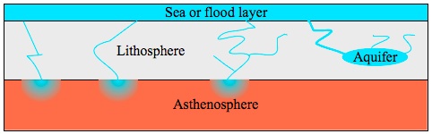
Magma-water contact lines may also be formed by water that seeps through systems of lithospheric cracks and fractions all the way down to the asthenosphere. The potential of the water absorption in this scenario is even greater than that of the marine volcanoes' scenario, since the lithosphere envelopes the entire planet.
To summarize this chapter, we see that the Bible demands a relatively rapid rate of absorption (500-1,500 meters per month at its peak), but this rate is much smaller than what may be inferred from a superficial reading of the Biblical description. I have proposed several models that may enable a rapid absorption of huge water quantities. These models should have worked only in the unique conditions of the Biblical flood, when the mantle "wished" to rebalance and re-absorb its original water. The different models do not depend on each other. They could have worked parallel to each other or separately. These models can be tested scientifically. Experiments can be conducted, within our present technical capabilities, to verify of disprove these models. I would be glad to cooperate with any scientist in this matter and also to receive new data on this issue.
As recalled from chapter 3, we identified 3 fundamental physical stages in the Biblical description of the flood. Stages 1-2 correlate with the water release and stage 3 correlates with the water absorption. The 150th day of the flood defines a clear border between the water release stages to the water absorption stage. Its cause has been explained in detail and connected to the departure of the cosmic cloud. On the other hand, the internal partitioning of the water release stage was not yet explained. We know that the 40th day of the flood defines the border between stages 1 and 2. But I did not yet supply any physical explanation for this border. Why was there a difference between the first 40 days to the following 110 days? Allegedly, Earth was still within the cosmic cloud all along this period. How could the physical conditions change and cause the described differences between stages 1 and 2?
1 John Dwyer, Douglas Wallace and Frank Hershey, Flood Tolerance Of Trees, Flooding and its effect on trees, United States Department of Agriculture. http://www.na.fs.fed.us/spfo/pubs/n_resource/flood/toler.htm
2 Pietro Bartolucci Buddhi Raj Dhakal, PROSPECTS FOR OLIVE GROWING IN NEPAL . Department of Agriculture, Fruit Development Division Olive Production Development Project, TCP/NEP/6713 & Food and Agriculture Organization of the United Nations Kathmandu 1999, ftp://ftp.fao.org/docrep/fao/008/af106e/af106e00.pdf
3 Alain Burgisser, James E. Gardner. Experimental Constraints on Degassing and Permeability in Volcanic Conduit Flow,Bulletin of Volcanology ,December 2004, Volume 67, Issue 1, pp 42-56
12. Astronomical and climatic insights on the stages of the flood
So far I have supplied detailed explanations for the water-release stages (stages 1-2 of the flood) and also for the water-absorption stage (stage 3 of the flood). But why were there two stages of water-release in the first place? First, forty days of continuous rain and then another 110 days of non-continuous rain accompanied by a continual increase in the water's level. I claim that the answer is connected with the variations in the relative velocities of the Earth and the cosmic cloud throughout this period. These variations affected the "flux" of the cosmic dust upon Earth. I will elaborate this issue immediately.
First of all, we must understand the concept "flux". Imagine that it is raining and that due to the strong rain the drops do not descend in a vertical path, but in an inclined path (see the following illustration). Who of the following will get wet faster? Mr. Waterlove, who runs against the direction of the drops, Mr. Apathetic who just stands still or Mr. Waterhate, who runs away from the drops? Let us assume that Mr. Waterlove and Mr. Waterhate run at the same speed.
A simple demonstration of the concept "flux": Mr. Waterlove, who runs against the direction of the rain drops, gets wet faster than Mr. Apathetic, who stands still and faster than Mr. Waterhate, because the flux of the rain drops upon him is the greatest. Mr. Waterhate gets wet slower than the others because the flux of the rain drops upon him is the smallest.
Of course, Mr. Waterhate gets wet slower than Mr. Waterlove and Mr. Apathetic gets wet at some intermediate level. The flux of the rain drops, i.e. the number of drops which hit a given area unit per time unit, is greater upon Mr. Waterlove than upon Mr. Apathetic and it is smallest upon Mr. Waterhate. Similarly, throughout Earth's passing within the cosmic cloud, the flux of the cosmic dust upon Earth varied in correlation to the variations in their relative velocities:
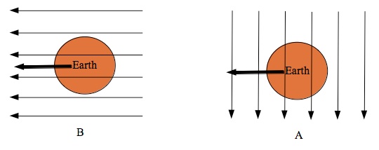
The flux of the cosmic dust upon Earth: Under the assumption that the speeds of Earth and the cosmic cloud are constant, variations in their relative directions caused variations in the flux of the cosmic dust upon Earth. In illustration A, the motion of the cloud is vertical to that of Earth. In illustration B, the cosmic cloud and Earth are moving in the same direction. These states are analogue to the states of Mr. Apathetic and Mr. Waterhate in the previous illustration. The flux in state B is necessarily lower than the flux in state A.
Let us assume that when the cosmic cloud initially encountered Earth, their velocities were in vertical directions (phase A in the following illustration). In this situation there is an intensive flux of meteoroids and/or cosmic dust at the first stage of the flood. The gravitational effects of the cosmic cloud may have disturbed Earth's regular motion, but Earth did continue to follow the general outlines of its solar orbit. Therefore, after the first 40 days Earth's velocity had changed its direction by more than 45 degrees in relation to the velocity of the cosmic cloud. Now Earth was generally moving together with the cosmic cloud (phase B in the following illustration). I should mention that I assume that the portions of the cosmic cloud, which encountered Earth, always arrived from the same general direction. This assumption makes sense when we understand that the cosmic cloud must have been so huge that its tail separated from Earth only 150 days after its head encountered it.
Changing the relative velocities of the Earth and the cosmic cloud, dramatically decreases the flux of the cosmic dust upon Earth. Hence, both the meteoroid flux, and the rate in which Earth was exposed to the tidal effects of different mass concentrations within the cosmic cloud, decreased. Therefore, the intensity and quantity of the rain decreased from continual to non-continual rain. After 3 months the flux was minimal (see phase C in the following illustration). Then the flux began to increase again. In chapter 7, I concluded that the cosmic cloud departed from Earth on the 150th day (phase D in the following illustration).
150 days are about 5 months. A vertical encounter with the cosmic cloud at the beginning of the flood leads to a similar condition 6 months later. Then the velocity of Earth should be vertical to that of the cosmic cloud once again. This estimation is of course inaccurate, since the gravity of the sun should bend the motion of the cloud to some extent. However, if we had spent 6 months within the cosmic cloud, then we would have experienced a reinforcement of the meteoroid shower and the rain. The fact that the Bible does not describe a second barrage of rain, implies that the cosmic cloud did indeed depart from Earth prior to this stage (after merely 5 months).
The last 3 paragraphs explain this illustration.
In addition to the above explanation, I assume that the waters of the great deep first burst out of the ground at high pressure. Then, as time passed, the quantity of water which remained in the depths of Earth decreased, and it became difficult to extract more water. Therefore, the initial bursting of the waters of the great deep should be the strongest. This effect must have also contributed in making the first 40 days of precipitation extremely wet.
After the 150th day of the flood, there was an immediate decrease in the quantity of the rain up to a total stop. "...The fountains also of the deep and the windows of heaven were stopped..." (Genesis 8: 2, King James' translation). It is evident why the meteoroid showers stopped, since there were no more meteoroids around us. The bursting of the waters of the great deep also stopped, since the tidal effects of the cosmic cloud quickly became negligible. But why did the rains completely stop? What about "normal" rains, which are routinely formed by atmospheric low pressure areas?
How are low pressure areas usually formed in the atmosphere?
Our planet does not absorb the solar radiation uniformly. The areas which are closer to the equator receive more radiation than those which are closer to the poles. The sea absorbs and preserves the solar energy better than the land. Different colors heat up at different rates, therefore even differences in the color of the ground or the presence of vegetation cause local variations in the absorption of solar radiation. These local and regional differences unevenly heat up the atmosphere. Hot air tends to ascend. Therefore, in relatively hotter regions of the atmosphere, air ascends to higher layers and hence generates lower pressure in the lower layers. It can be inferred that without the presence of solar radiation the whole mechanism quickly losses its drive.
We must take into account that the cosmic cloud also blocked the solar radiation that usually heats Earth up. Earth's atmosphere would quickly lose its heat in the absence of solar radiation. Just notice the daily temperature difference between day and night and imagine that the night would continue throughout several months. Earth's surface would quickly freeze. Fortunately, Earth's internal heat was pushed out into its hydrosphere and atmosphere together with the waters of the great deep. This heat counterbalanced the lack of the solar radiation. But since it is explicitly mentioned in the Bible that after the 150th day the rain completely stopped, we must assume that the worldwide ocean that was formed in the flood, had already cooled down considerably at this stage.
The solar radiation may have also been blocked by dust, which remained in the higher layers of the atmosphere for many months. The source of this dust may be related to shredded meteoroid components as well as to typical volcanic dust. Without sufficient solar radiation low pressure areas were not generated, "regular" storm clouds were not formed and the rain totally stopped. In such conditions, a global and total cessation of the rains seems reasonable.
Yalkut Shimoni is a rabbinical composition, which was compiled by an unknown author in medieval Germany. The author collected various interpretations and explanations of Biblical passages from the Jewish legends. Referring to the Biblical flood he wrote:
"...God covered the sun and the Moon and they did not shine for 12 months..."
(Yalkut Shimoni, Genesis, section 57)
-
Once again I thank Uriel Farjon for this information.
At this point I can state that the theory has explained and covered all the physical aspects of the Biblical flood in great detail (besides the famous rainbow, which demands further research). The theory accurately matches the Biblical description instead of regarding it as an exaggerated description. But as for now, it is still just a theory. Let us now summarize our new insights and conclusions and check which scientific domains must be further investigated in order to prove or disprove this theory.
13. Summary and conclusions
Summary of the conclusions in each chapter:
Chapter 2: Regional flood or global flood?
The most accepted theory in the academic community today (2012) relates the flood "myth" to the regional flooding of the Black Sea about 7,600 years ago. I have explained in detail why this theory cannot accurately satisfy the Biblical description of the flood. Neither can this theory match the Biblical dating of the flood. I have also referred to the claims, which make use of a few rabbinical sources to show that the flood was regional and not global. I showed that these claims contradict the commentaries of the most venerable rabbinical sages: Rashi, Ibn Ezra and Ramban. If we wish to seek an explanation that genuinely and accurately matches the Bible, we must recognize that the flood was indeed global.
Chapter 3: The stages of the flood
Using the commentaries of Rashi, Ibn Ezra and Ramban, I reanalyzed the Biblical text and determined 3 major physical stages within the flood:
-
Stage 1: 40 days of continuous rain.
-
Stage 2: 150 days in which the water "prevailed" upon the earth. This stage may have included stage 1.
-
Stage 3: The calm and prolonged decrease of the water's level (about half a year).
I then claim that any physical theory, which presumes to accurately describe the Biblical flood, must first explain how a global flood occurred and then satisfy the 3 stages of the flood according to their order and duration.
Chapter 4: Can the flood be explained as a mega-tsunami?
In this chapter, I argue that a "normal" tsunami is merely regional and it lifts the sea level by no more than several dozens of meters, thus it cannot generate a global flood. An asteroid impact may generate mega-tsunamis which may indeed cover vast areas of land, but it does not cause the hydrosphere to swell and its duration is short. Therefore, the mega-tsunami scenario does not satisfy the third stage of the flood and by itself it cannot explain the Biblical flood.
Chapter 5: Can the flood be explained as an extreme tide?
A close encounter with a massive celestial body, such as an asteroid, a comet or another planet may generate an extreme tide of the oceans. However, I conclude that the Biblical flood had not been caused by such phenomena alone. Why?
-
Because close encounters with celestial bodies are expected to be very short in their duration and as we know the Biblical flood lasted about a year.
-
Because such intense tides would have caused intense tidal currents. This may have been the case throughout stages 1-2 of the flood, but in the third stage it is explicitly mentioned that the waters calmed down.
-
Because the waters of the extreme tide scenario originate only from the existing reservoir of the hydrosphere. But this reservoir cannot supply enough water to sustain the stable and prolonged flood, which is described in the Bible.
Chapter 6: Clues for the true nature of the flood?
In chapter 6 we investigate the essence of "the windows of heaven" and "the fountains of the great deep". I emphasized the simultaneity of their opening and breaking. Based on our investigation it seems straightforward to argue that the opening of "the windows of heaven" was equivalent to blurring the separation, which Space itself forms between Earth and the celestial bodies. Since the scenarios of an asteroid impact or an extreme tide (due to some close encounter with a celestial body) were disproved in the previous chapters, I argued that the swallowing of Earth by a cosmic cloud may fit the Biblical description.
In our investigation we saw that "the fountains of the great deep" do not relate to "regular" ground waters, but to waters from far greater depths. Since the sea level has not changed significantly in relation to the pre-flood era, I concluded that most of the water must have originated from "the great deep" and returned there at the end of the flood. Despite the allegedly contradicting geological data, I postulated that the depths of Earth do contain enough water to supply the Biblical flood. Then I argued that the intense tidal forces, which were generated when Earth passed through the cosmic cloud, somehow caused the waters of the great deep to burst upwards simultaneously with the bombarding of Earth by massive meteoroid showers. These postulates and arguments demanded further investigation in the following chapters.
Chapter 7: How much water?
The same intense tidal forces, which allegedly pulled the waters of the great deep up to the surface, must have also generated intense tides in the oceans (hundreds or even thousands of meters high). Since the Bible explicitly mentions that at the peak of the flood the highest mountain was submerged under no more than 15 cubits of water, it follows that this was the maximal level of the highest high-tide and not of the "real" flood level. Taking into account also the well known effects that local topographies may have on high tides, it was just reasonable to argue that the "real" flood level should have been lower than the highest mountain by hundreds and maybe even thousands of meters. I mentioned that I am not at all certain that the topography of the pre-flood era was identical to our present topography. The intense forces which acted upon Earth throughout the Biblical flood may have accelerated tectonic activity and substantially lifted the Himalayas.
After we understood that the "real" level of the flood must have been substantially lower than the highest mountain, we continued to seek for more information regarding this issue in the Bible and its commentaries as well as in the topographic features of Mount Ararat and its region. The research led us to deeply investigate the great dispute between Rashi, Ibn Ezra and Ramban. It became evident that Ramban's scenario was the most physically plausible. From this insight it followed that the cosmic cloud departed from Earth on the 150th day of the flood. Hence, the strongest tides occurred on that day. The maximal high tide locally rose 15 cubits above the highest mountain and then on that same day the water level decreased to its real flood level, that was even lower than the top of Mount Ararat. The whole analysis led us to conclude that the real flood level was no higher than 5,137 meters (16,854 feet) and no lower than 3,000 meters (9,842 feet). Therefore, in order to satisfy the Biblical flood a quantity of water greater than 1.15 oceanfolds and smaller than 1.98 oceanfolds must have been added to the hydrosphere.
Chapter 8: Where is the water?
In this chapter I first supplied basic information about Earth's inner structure. Then we investigated new data from recent researches regarding the quantities of water that are dissolved within the rocks and the magma of the mantle and core. It became evident that the quantities of water in Earth's interior far exceed the necessary quantity for the Biblical flood, thus the assumption from chapter 6 was in fact proved. Based on different geological evidence, I postulated the existence of a "planetary water cycle".
Chapter 9: The Planetary Water Cycle
In the beginning of this chapter we postulated that a chemical and physical balance exists between the waters of the oceans and the waters of Earth's interior. How does this hypothetical balance work? For this I proposed two possibilities, which seemed different at first, but combined with each other later on:
-
All the layers of the mantle and core are saturated with water.
-
The mantle and core contain layers in a variety of states: under-saturated, saturated and over-saturated. The balance is preserved due to combinations of water filtering layers, diffusion between layers and water transportation in the mantle's currents. In the general picture, but not necessarily in the local one, the core and mantle are saturated with water.
I have provided a detailed explanation, which is backed up by recent geophysical and geochemical data, for two possible models of the Planetary Water Cycle.
Chapter 10: The water release
The extreme tidal forces, which acted upon Earth during its passing through the cosmic cloud, caused the planetary water cycle to lose its balance and hence great quantities of water were released from the mantle and maybe even from the core. The gravitational energy that Earth absorbed through the tides was quickly transformed into heat. Most of the heat was naturally absorbed by the transition and discontinuity zones, which are partially melted and therefore more elastic. These layers were further melted and widened. The heating and extensive melting decreased the saturation levels of vast areas in the mantle and hence caused them to release their waters upwards. Temporary decompression at high tides also contributed to temporarily decrease the melting temperatures. The repeating squeezing of Earth by the tides accelerated the formation of water bubbles just like the shaking of a coca cola bottle accelerates the formation of carbon dioxide bubbles. The excess water was released to the hydrosphere and atmosphere through volcanic activity and through cracks in the lithosphere. The water release also enabled Earth to quickly release its excess heat back to Space in a mechanism that was named "The Planetary Radiator". This chapter contains extensive explanations for all these issues and more.
Chapter 11: The water absorption
In this chapter we first tried to estimate the rate in which the water was absorbed. Using the Biblical details from the story of the raven and dove together with recent data on the growth of olive trees at altitudes of 1,000-2,000 meters (3,280-6,560 feet), enable us to estimate the rate in which the water level decreased as some value within the range 500-1,500 meters (1,640-4,920 feet) per month. This rate is relevant for the middle of the third stage of the flood. I then showed that we lack sufficient data to determine the rate of water decrease at the final stage of the flood. It may have taken many months or even years after Noah exited the ark until the sea returned to its regular level. In general, this analysis shows that the rate in which the water was absorbed was not as rapid as it is usually perceived.
Once Earth separated from the cosmic cloud, its interior began to cool down to its regular temperature. When the rocks and magma began to cool down, their saturation concentrations increased and they became "thirsty". Supercritical water could have easily dissolved into the magma and diffused back into the mantle, first of all into the asthenosphere. Volcanoes acted as bottlenecks. Their magma could not reach saturation as long as oceans of magma beneath them didn't also reach saturation. I also mentioned the possibility that the lithosphere was cracked after the flood in a manner that enabled great quantities of water to seep down all the way to the asthenosphere. Hence, another water-magma contact line was formed along the lithosphere-asthenosphere boundary through which water could have easily dissolved into the mantle.
In the "Melting-Transporting-Solidifying" scenario I demonstrated how water can pave its own relatively quick path down to the depths of the mantle straight through solid layers.
Chapter 12: Astronomical and climatic insights on the stages of the flood
In this chapter I explained the partition of the water release phase into its 2 inner stages, 40 days of continuous rain and then 110 days of non-continuous rain accompanied by a continuous increase in the water's level. I showed how the natural movement of Earth in its solar orbit generated variations in the flux of the cosmic dust upon it, which contributed to decrease of the rain after 40 days. In addition, the analysis of the flux variations reinforced the claim that the cosmic cloud must have departed Earth on the 150th day of the flood.
I also asked, why had the rain completely stopped at the third stage of the flood. I explained that the solar radiation must have been blocked throughout the flood due to the cosmic dust and the volcanic ash. Hence "regular" low pressure areas together with their storm-clouds were not formed.
Necessary side effects:
-
Intense volcanic activity, at least up to the 150th day of the flood.
-
Worldwide evidence for a massive, but very short (in geological terms), flooding.
-
An abrupt climate event, accompanied by a cold spike, after the entire climatic system was rebooted.
-
All of the human settlements should have emptied of their inhabitants simultaneously.
-
A substantial and global damage to both terrestrial and marine flora and fauna.
Plausible side effects:
An influence on Earth's motion patterns (variations in its orbit, rotation, axial tilt and so on...). Similarly, other planets and their moons may have also experienced variations in their motion patterns.
Do not rush to disregard...
"The Physics of The Biblical Flood" is merely the first chapter of an extensive research that I have conducted over the previous years. At this stage, I am asking scientists to focus only on the analysis, proving or disproving of the claims which are given within this book. Please do not rush to make claims of the following type:
"The theory may be possible, but there is no evidence that its scenario actually occurred..."
I declare that I do have geological, archeological, biological and anthropological evidence to strengthen this theory. I am preparing the material for presentation, but the quantity is massive and the process may take months and maybe even several years.
Final words:
I have read many books which present their theories as the ultimate and indisputable truth. By doing so, the authors deceive the common readers. Even if their theories are in fact the ultimate truth, it is wrong to present any scientific theory in this manner. The readers must understand that any scientific theory is actually a "logical system", which is always based on a series of fundamental assumptions called "postulates" or "axioms". These fundamental assumptions are left without proof, because they just seem obvious or because it is difficult to prove them and the theory has to start from some point. For example, the whole logical system that we call "arithmetic" is based upon the fundamental assumption that 1+1 = 2. Most of the scientific theories that practically work do not tend to collapse later on, but they are nearly always "corrected". For example, classic physics did not collapse when modern physics appeared. It was corrected. Newton wasn't wrong. He was inaccurate. He was inaccurate in some of his postulates. From the correction of a postulate the correction of the whole theory follows. A scientist should always know the limits of his theory and remember that even if his logic was correct, his postulates may be found inaccurate or wrong later on.
Therefore, since I wish to change the manner in which science is presented to the public I encourage the reader to have some doubt. I totally believe in my theory and yet I declare that it would be scientifically wrong to regard it as an indisputable truth. Criticism is an integral part of science and due to it we improve. Anyone who wishes to criticize my theory in a genuine and scientific manner will receive my full attention. If errors are found, I will publicly admit them. The scientific and spiritual truth is more important than my ego.
I plan to continue to prepare the other parts of the theory for presentation. I cannot properly present the following parts of my research without first discussing the greatest "contradictions" between science and the book of Genesis: the creation, evolution, the origins of mankind and the pre-flood era. These will be the issues of my next book. Using ancient spiritual knowledge, we may soon reach our deepest scientific understanding of these issues.
Feel free to contact me by email with any questions or issues.
Roi Lotan Glazer
14. Bibliography
The Bible and its commentaries:
All the quotations from the Bible in this book are taken from The Holy Bible, King James version Electronic Text Center, University of Virginia Library. http://etext.virginia.edu/toc/modeng/public/KjvGene.html
The commentaries of Rashi and Ibn Ezra and Ramban were personally by myself translated from Hebrew. The commentaries of Rashi and Ibn Ezra were quoted from the Hebrew Source:
.(October 2012),אדמו"ר מנחם מענדל שליט"א. שבוע פרשת נח, דבר מלכות.מאמרי דא"ח, אוצר החסידים. שיחות ואגרות קודש. ה'תשע"ג
The commentaries of Ramban were quoted from the Hebrew Source:
.(2012) ,מכללת הרצוג- לימודי יהדות ורוח. שבילי התנ"ך. באתר דעת
http://www.daat.ac.il/daat/olam_hatanah/index.asp
Sources in Hebrew:
.2009 ,בליזובסקי אבי, המבולהמבול של נוח לא היה כל כך חזק. הידען. 28 בינואר
http://www.hayadan.org.il/danube-delta-holds-answers-to-noahs-flood-debate-2801091
.2000 בליזובסקי אבי, תיבת נוח האמיתית- נמצאו ממצאים מתרבות שהוצפה במי הים השחור. הידען.31 באוגוסט
http://www.hayadan.org.il/noach310800
.2000, מלמד הדסה, סוד המבול, משולש ברמודה המסתורי ונדידת היבשות
.קווה משה, המבול והמדע. הדף השבועי לפרשת נח- שנת ה'תשס"ב, אוניברסיטת בר-אילן
http://www.biu.ac.il/jh/parasha/noah/noah.shtm
.2008 ,ריאן ויליאם, פיטמן וולטר. המבול של נוח- פרק ראשון. הידען. 12 באפריל
http://www.hayadan.org.il/noahs-flood-first-chapter-1204083
Sources in English:
Akmaev Rashid. Does the Moon have a tidal effect on the atmosphere as well as the oceans? Scientific American. August 7, 2006. http://www.scientificamerican.com/article.cfm?id=does-the-moon-have-a-tida
Bartolucci Pietro, Dhakal Raj Buddhi , Prospects for olive growing in Nepal. Department of Agriculture, Fruit Development Division Olive Production Development Project, TCP/NEP/6713 & Food and Agriculture Organization of the United Nations Kathmandu 1999, ftp://ftp.fao.org/docrep/fao/008/af106e/af106e00.pdf
Bercovici, E., and S.-I. Karato, Whole-mantle convection and the transition -zone water filter, Nature, 425, 39-44, 2003.
Bolfan-Casanova N. , Water in the Earth's mantle, doi: 10.1180/ 0026461056930248; Mineralogical Magazine June 2005 v. 69 no. 3 p. 229-257, http://minmag.geoscienceworld.org/content/69/3/229.abstract
Burgisser Alain, Gardner E. James. Experimental Constraints on Degassing and Permeability in Volcanic Conduit Flow,Bulletin of Volcanology ,December 2004, Volume 67, Issue 1, pp 42-56
Charette A. Matthew and Smith H.F. Walter . The Volume of Earth's Ocean. Oceanography. Volume 23. Number 2. (2010). http://www.tos.org/oceanography/issues/issue_archive/issue_pdfs/23_2/23-2_charette.pdf
Department Of Terrestrial Magnetism, Carnegie Institution For Science, The Jupiter Satellite Page, 2012. ht tp://www.dtm.ciw.edu/users/sheppard/satellites/
Dwyer John, Wallace Douglas and Hershey Frank, Flood Tolerance Of Trees, Flooding and its effect on trees, United States Department of Agriculture. 2012. http://www.na.fs.fed.us/spfo/pubs/n_resource/flood/toler.htm
Encyclopedia Britannica Online, s. v. , asthenosphere, accessed January 15, 2013, http://www.britannica.com/EBchecked/topic/39770/asthenosphere.
Encyclopedia Britannica Online, s. v. , Saturn, Web. 04 Dec. 2012. < http://www.britannica.com/EBchecked/topic/525169/Saturn/54278/Basic-astronomical- data > and < http://www.britannica.com/EBchecked/topic/525169/Saturn/54280/The-interior >.
Fleming Kevin ,Johnston Paul, Zwartz Dan, Yokoyama Yusuke, Lambeck Kurt and Chappell John. Refining the eustatic sea-level curve since the Last Glacial Maximum using far- and intermediate-field sites. Earth and Planetary Science Letters 163 (1-4): 327-342. (1998). doi: 10.1016/S0012-821X(98)00198-8
Fortney, Jonathan J.; Nettelmann, Nadine, The Interior Structure, Composition, and Evolution of Giant Planets, Space Science Reviews 152 (1-4): 423-447,(May 2010). arXiv:0912.0533, Bibcode2010SSRv..152..423F,doi: 10.1007/s11214-009-9582-x
Gillan, Michael J.; De Wijs, Gilles A.; Kresse, Georg; Vočadlo, Lidunka; Dobson, David; Alfè, Dario; Price, Geoffrey D. The viscosity of liquid iron at the physical conditions of the Earth's core. Nature 392 (6678): 805. (1998).Bibcode 1998Natur.392..805D. doi:10.1038/33905.
Hidenori Terasaki, Eiji Ohtani, Takeshi Sakai, Seiji Kamada, Hidetoshi Asanuma, Yuki Shibazaki, Naohisa Hirao, Nagayoshi Sata, Yasuo Ohishi, Tatsuya Sakamaki, Akio Suzuki, Ken-ichi Funakoshi, Stability of Fe-Ni hydride after the reaction between Fe-Ni alloy and hydrous phase (δ-AlOOH) up to 1.2Mbar: Possibility of H contribution to the core density deficit , Physics of the Earth and Planetary Interiors, Volumes 194-195, March 2012, Pages 18-24, ISSN 0031-9201, 10.1016/j.pepi.2012.01.002. http://www.sciencedirect.com/science/article/pii/S0031920112000039
H. Sigurdsson et al. Encyclopedia of Volcanoes, San Diego, Academic Press, (2000).
International Association for the Properties of Water and Steam,Revised Release on Viscosity and Thermal Conductivity of Heavy Water Substance. 2007. http://www.iapws.org/relguide/TransD2O-2007.pdf
Ivanov I. Leonid and Oguz Temel. Ecosystem modeling as a management tool for the black sea. Nato science series, 2. Environmental Security- Vol. 2, page 1 (1997). http://www.springer.com/earth+sciences+and +geography/oceanography/book/978-0-7923-5245-7
JetStream. Online School For Weather. National Weather Service. NOAA. Tsunami. 2012. http://www.srh.noaa.gov/jetstream/tsunami/tsunami_faq.htm
Karato Shun-ichiro , Bercovici David , Leahy Garrett, Guillaume Richard and Zhicheng Jing. The Transition-Zone Water Filter Model for Global Material Circulation: Where Do We Stand?, Yale University, Department of Geology and Geophysics, New Haven. 2006. http://earth.geology.yale.edu/~dberco/papers/2006/WaterFilter-AGU-Monograph2006.pdf
Kerr, R. A., Magnetics Point to Magma 'Ocean' at Io. Science 327 (5964): 408-409. (2010).doi:10.1126/science.327.5964.408-b. PMID 20093451.
Kious Jacquelyne W. and Tilling I. Robert, U.S. Department of Interior, This Dynamic Earth: The Story of Plate Tectonics, 1996. http://pubs.usgs.gov/gip/dynamic/dynamic.html#anchor10790904
Lawrence F. Jesse. Wysession E. Michael. Seismic Evidence for Subduction-Transported Water in the Lower Mantle. 2005_MONOGRAPH. http://epsc.wustl.edu/seismology/michael/web/lawrence_and_wysession_2005_MONOGRAPH.pdf
Louie J., Earth's Interior. The Nevada Seismological Laboratory, University of Nevada, Reno. (10 Oct. 1996). http://crack.seismo.unr.edu/ftp/pub/louie/class/100/interior.html
Newman L. William, Geological Time, U.S. Geological Survey. 1997. http://pubs.usgs.gov/gip/geotime/contents.html
Robertson C. Eugene, U.S. Geological Survey, The interior of the Earth, 01-14-11. http://pubs.usgs.gov/gip/interior/
Rosaly MC Lopes. Io: The Volcanic Moon. In Lucy-Ann McFadden, Paul R. Weissman, Torrence V. Johnson. Encyclopedia of the Solar System. Academic Press. pp. 419-431. (2006). ISBN 978-0-12-088589- 3.
Schenk, P.; et al., The Mountains of Io: Global and Geological Perspectives from Voyager and Galileo". Journal of Geophysical Research 106 (E12): 33201-33222. (2001). Bibcode2001JGR...10633201S. doi:10.1029/2000JE001408.
Trimel Suzanne, Discovery of Human Artifacts Below Surface of Black Sea Backs Theory by Columbia University Faculty of Ancient Flood. Columbia University, NYC. 09/13/00. http://www.earthinstitute.columbia.edu/news/story9_1.html
Valleley Sofia. Keeping the Earth's plates oiled. European Science Foundation. 1. June 2007. http://www.esf.org/research-areas/life-earth-and-environmental-sciences/news/ext-news-singleview/article/keeping-the-earths-plates-oiled-296.html
Velikovsky Immanuel. With the assistance of his daughter Shulamit I have used different flood related manuscripts and articles, which were written by Immanuel Velikovsky throughout the years, but were never published as a book. During the preparation of this book Shulamit decided to upload all the relevant material to her website: www.agesinchaos.org.il
Wallace, P. J. , Water and partial melting in mantle plumes: Inferences from the dissolved H2O concentrations of Hawaiian basaltic magmas, Geophys. Res. Lett., 25(19), 3639-3642, doi:10.1029/98GL02805. (1998).
Wahr John, Global Earth Physics, Earth Tides, A Handbook of Physical Constants, AGU Reference Shelf, 1,, pp. 40-46, 1995.
Winkler Peter , National Geographic Society. Ballard- The Black Sea, The Search for Noah's flood. 1999.h ttp://www.nationalgeographic.com/blacksea
Yellowstone Volcano Observatory. Volcano Hazards Program. USGS. Dissolved Volatile Concentrations in Melt Inclusions. 4.17.2012. http://volcanoes.usgs.gov/observatories/yvo/jlowenstern/meltinclusions/volatiles.php